-
Fukushima radioactive plume to reach U.S. next year
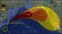
The radioactive ocean plume from the 2011 Fukushima nuclear plant disaster will reach the shores of the United States within three years from the date of the incident, but is likely to be harmless, according to a new study. While atmospheric radiation was detected on the U.S. west coast within days of the incident, the radioactive particles in the ocean plume take considerably longer to travel the same distance.
-
-
Understanding the effects of wildfire smoke improves climate change models
Where there is wildfire, there is smoke — a lot of it. Those vast, carbon-laden clouds released by burning biomass can play a significant role in climate change. Not much is known, however, about the different types of particles in wildfire smoke and how they affect climate. Now researchers have uncovered some of their secrets. In particular, they studied an important component of smoke that has so far been absent from most models of climate change.
-
-
3D Earth model accurately pinpoints source of earthquakes, explosions
During the cold war, U.S. and international monitoring agencies could spot nuclear tests and focused on measuring their sizes. Today, they are looking around the globe to pinpoint much smaller explosives tests. Researchers are working on developing a 3-D model of the Earth’s mantle and crust called SALSA3D. The purpose of this model is to assist the U.S. Air Force and the international Comprehensive Nuclear-Test-Ban Treaty Organization (CTBTO) in Vienna, Austria, more accurately locate all types of explosions.
-
-
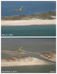
Beach erosion by Hurricane Sandy leaves coastal communities more exposed to future storms
Barrier islands provide natural protection against storms, shielding coastlines from rising waves and tides. Beaches and dunes on Fire Island, New York, lost more than half of their pre-storm volume during Hurricane Sandy, and the loss of so much sand increases the vulnerability of this area of coastline to future storms.
-
-
Remapping coastal areas damaged by Hurricane Sandy
Hurricane Sandy caused wide-scale landscape-altering destruction, resulting in an estimated damage of $50 billion, making Sandy the second-costliest cyclone to hit the United States since 1900. “Sandy’s most fundamental lesson is that storm vulnerability is a direct consequence of the elevation of coastal communities in relation to storm waves,” says USGS Kevin Gallagher. Three federal agencies are using ships, aircraft, and satellites to measure water depth, look for submerged debris, and record altered shorelines in high priority areas from South Carolina to Maine.
-
-
Demolition of building allows study of earthquake along Calif. Hayward Fault
In an effort to track which area of California’s East Bay would suffer the worst shaking in future earthquakes caused by the dangerous Hayward Fault, the U.S Geological Survey (USGS) initiated an artificial earthquake through the densely populated area of valleys and hills across bay from San Francisco.
-
-
Aquifer supplying a third of U.S. irrigated groundwater depleting quickly: study
The High Plains Aquifer of Kansas — also called the Ogallala Aquifer — supplies 30 percent of the U.S. irrigated groundwater. New study finds that if current irrigation trends continue, 69 percent of the groundwater stored in the High Plains Aquifer will be depleted in fifty years.
-
-
Post-Sandy infrastructure must be more resilient: Sandy Task Force
The task force appointed by President Barack Obama, charged with developing a strategy for rebuilding areas damaged by Superstorm Sandy, has urged coastal communities to recognize that owing to climate change, storms are going to be more frequent and more destructive, and that floods are going to occur more frequently. The best way to prepare for the more extreme weather ahead is to build a more robust and resilient infrastructure that can withstand the more demanding challenges.
-
-
Predicting when lightning will strike
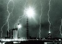
When something is unlikely to happen, people often say that there is a greater chance of being struck by lightning. The fact is, however, that lightning does strike, and is one of the leading weather-related causes of death and injury. Furthermore, important infrastructure including airports, hospitals, sports stadiums, and power lines can often be affected by lighting. Electronic components are particularly vulnerable to lightning-induced transient voltages. Lightning is estimated to cause up to 16 percent of forest fires in the EU, costing 70 million euros in mitigation efforts a year. The EU-funded LOLIGHT (Lightning Mapping and Supercell Tracking System) project sought to address this by developing a low-cost system capable of detecting lightning to an accuracy of 100 meters.
-
-
New levee system offers New Orleans better protection
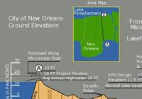
With the busiest period of the 2013 hurricane season approaching metro New Orleans, the area is ready to face the challenge with a flood control system worth about $14.5 billion. The network of levees, floodwalls, and pumps, its designers say, should nearly eliminate the risk of flooding from most hurricanes, and substantially reduces flooding from hurricanes the size of 2005 Hurricane Katrina.
-
-
Catastrophes cost global insurance industry more than $20 billion in first half of 2013
Total economic losses from disasters in the first half of 2013 reached $56 billion. Insured losses from natural catastrophes totaled $17 billion, with flooding a main driver. Around 7,000 lives were lost as a result of natural catastrophes and man-made disasters.
-
-
Cost of flood losses in major coastal cities to exceed $50 billion by 2050
A new study estimate present and future flood losses — or the global cost of flooding — in 136 of the world’s largest coastal cities, taking into account existing coastal protections. Average global flood losses in 2005, estimated at about $6 billion per year, could increase to $52 billion by 2050 with projected socio-economic change alone. Due to their high wealth and low protection level, three American cities — Miami, New York City, and New Orleans — are responsible for 31 percent of the losses across the 136 cities.
-
-
Investigating earthquake retrofits for “soft” first-floor buildings
A team of researchers has spent the last month shaking a four-story building on the world’s largest outdoor shake table at the University of California, San Diego, to learn how to make structures with first-floor garages better withstand seismic shocks. Since July, the team has successfully tested a variety of earthquake retrofits on a full-scale, 44,000-square-foot building built specifically for the tests at the Englekirk Structural Engineering Center at UCSD. The structure — three stories atop an open first floor — has survived three of four simulated seismic events of increasing strength on the shake table.
-
-
Artists join scientists to plot disaster scenarios
Researchers investigate how human and software agents can effectively work together to collect the best possible information from a disaster environment. The researchers have been exploring the use of unmanned autonomous systems (UAS) fitted with audio-visual equipment that can improve the response of emergency services and populations to disaster management. The team will be joined by two artists who will challenge the researchers to imagine new disaster scenarios that UAS technology may have to respond to.
-
-
Sandy shows need for more effective preparedness, resiliency standards
The rebuilding efforts following the devastation wreaked by Superstorm Sandy have triggered a discussion over preparedness and resiliency in America’s commercial and residential buildings.Some experts callfor a presidential appointment of a building resilience “’czar”’ with authority to coordinate and seek synergies between public and private sector initiatives.
-
The long view
Using Drone Swarms to Fight Forest Fires
Forest fires are becoming increasingly catastrophic across the world, accelerated by climate change. Researchers are using multiple swarms of drones to tackle natural disasters like forest fires.
How Climate Change Will Affect Conflict and U.S. Military Operations
“People talk about climate change as a threat multiplier,” said Karen Sudkamp, an associate director of the Infrastructure, Immigration, and Security Operations Program within the RAND Homeland Security Research Division. “But at what point do we need to start talking about the threat multiplier actually becoming a significant threat all its own?”