-
3D Earth model accurately pinpoints source of earthquakes, explosions
During the cold war, U.S. and international monitoring agencies could spot nuclear tests and focused on measuring their sizes. Today, they are looking around the globe to pinpoint much smaller explosives tests. Researchers are working on developing a 3-D model of the Earth’s mantle and crust called SALSA3D. The purpose of this model is to assist the U.S. Air Force and the international Comprehensive Nuclear-Test-Ban Treaty Organization (CTBTO) in Vienna, Austria, more accurately locate all types of explosions.
-
-
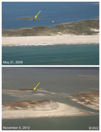
Beach erosion by Hurricane Sandy leaves coastal communities more exposed to future storms
Barrier islands provide natural protection against storms, shielding coastlines from rising waves and tides. Beaches and dunes on Fire Island, New York, lost more than half of their pre-storm volume during Hurricane Sandy, and the loss of so much sand increases the vulnerability of this area of coastline to future storms.
-
-
Remapping coastal areas damaged by Hurricane Sandy
Hurricane Sandy caused wide-scale landscape-altering destruction, resulting in an estimated damage of $50 billion, making Sandy the second-costliest cyclone to hit the United States since 1900. “Sandy’s most fundamental lesson is that storm vulnerability is a direct consequence of the elevation of coastal communities in relation to storm waves,” says USGS Kevin Gallagher. Three federal agencies are using ships, aircraft, and satellites to measure water depth, look for submerged debris, and record altered shorelines in high priority areas from South Carolina to Maine.
-
-
New technology improves IED detection
Improvised explosive devices, or IEDs, are homemade bombs that can both injure and kill civilians and service members. One solution to the problem of IEDs is to find them before they explode by detecting the chemicals used in the explosives. Scientists at the U.S. Naval Research Laboratory (NRL) have developed a technology, using silicon to fabricate a sensor that may revolutionize the way trace chemical detection is conducted
-
-
Unmanned undersea platform network to help better deploy naval capabilities
Today’s naval forces rely primarily on highly capable multifunctional manned platforms, such as ships and submarines. Even the most advanced vessel, however, can only be in one place at a time, making the ability to respond increasingly dependent on being ready at the right place at the right time. New Hydra program aims to make it easier, faster, and cheaper to deploy crucial capabilities worldwide.
-
-
Young scientists to tackle DoD’s most demanding technological challenges
A group of twenty-five early-career scientists at research universities have received grants totaling more than $12 million for basic research to address some of the Department of Defense’s (DoD) most challenging technological hurdles. The long-term goal of the DARPA Young Faculty Award (YFA) program is to develop the next generation of scientists and engineers who will focus their careers and research on DoD and national security issues.
-
-
World's smallest drone may be a search-and-rescue tool
Researchers have designed, built, and tested the world’s smallest open source autopilot for small unmanned aircraft. A smaller and lighter autopilot — it weighs only 1.9 grams — allows these small flying robots to fly longer, fit into narrower spaces, or carry more payloads such as cameras. This makes them more suitable to be used, for example, rescue operations.
-
-
Bay Bridge repairs expensive, slow
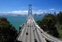
California’s 8-mile San Francisco-Oakland Bay Bridge was designed and built in the 1930s in about 5.5 years at a cost of $78 million, well under budget and ahead of schedule. Presently, the 2-mile eastern span of the bridge needs to be replaced, and it has taken the state five years just to design the replacement. Construction is taking about three times the expected time, and the $6.4 billion budget is almost five times the estimate provided by engineers.
-
-
Aquifer supplying a third of U.S. irrigated groundwater depleting quickly: study
The High Plains Aquifer of Kansas — also called the Ogallala Aquifer — supplies 30 percent of the U.S. irrigated groundwater. New study finds that if current irrigation trends continue, 69 percent of the groundwater stored in the High Plains Aquifer will be depleted in fifty years.
-
-
Post-Sandy infrastructure must be more resilient: Sandy Task Force
The task force appointed by President Barack Obama, charged with developing a strategy for rebuilding areas damaged by Superstorm Sandy, has urged coastal communities to recognize that owing to climate change, storms are going to be more frequent and more destructive, and that floods are going to occur more frequently. The best way to prepare for the more extreme weather ahead is to build a more robust and resilient infrastructure that can withstand the more demanding challenges.
-
-
A flying car is developed for the U.S. military
Flying cars would enhance the mobility of soldiers. Transportation will no longer be restricted to trafficable terrain that makes movement predictable and easy to track, and a flying car will enhance capabilities for resupply operations, fire-team insertion and extraction, and medical evacuation — reducing timelines and increasing the probability of survival.
-
-
ASIS Annual Seminar and Exhibit “the epicenter for security education and technology”
ASIS Annual Seminar and Exhibit, which will take place 24-27 September in Chicago, may well be the epicenter for security education and technology, says Geoff Craighead, ASIS president. With a show floor spanning 230,000 sq. feet, attendees from more than eighty countries, more than 200 education sessions, and a variety of ways to connect with colleagues and strengthen business relationships, ASIS 2013 is the place to be.
-
-
Long-term radiation effects: Chernobyl’s lessons for Fukushima
The Fukushima Daiichi nuclear disaster spread significant radioactive contamination over more than 3,500 square miles of the Japanese mainland in the spring of 2011. Now several recently published studies of Chernobyl are bringing a new focus on just how extensive the long-term effects on Japanese wildlife might be.
-
-
Predicting when lightning will strike
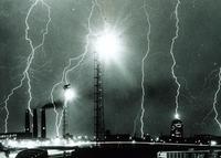
When something is unlikely to happen, people often say that there is a greater chance of being struck by lightning. The fact is, however, that lightning does strike, and is one of the leading weather-related causes of death and injury. Furthermore, important infrastructure including airports, hospitals, sports stadiums, and power lines can often be affected by lighting. Electronic components are particularly vulnerable to lightning-induced transient voltages. Lightning is estimated to cause up to 16 percent of forest fires in the EU, costing 70 million euros in mitigation efforts a year. The EU-funded LOLIGHT (Lightning Mapping and Supercell Tracking System) project sought to address this by developing a low-cost system capable of detecting lightning to an accuracy of 100 meters.
-
-
Collaboration with industry leads to improved forensics
Three-dimensional (3D) scanners used at crime scenes for forensic investigations are not just the stuff of prime time television. Investigators and crime laboratories are using 3D laser scanning measurement systems to measure and model, in 3D simulations, the critical aspects of crime scenes. A 2009 National Academy of Sciences (NAS) report, however, questioned the reliability of some forensic sciences, including the use of 3D scanning technique. Furthermore, pressure began building in the forensics community to have crime laboratories and stand-alone crime scene units in the United States adhere to specific standards in their services, which require traceability to the SI [the SI in SI traceability refers to the International System of Units (Système International d’unités)].
-
The long view
Autonomous Vehicle Technology Vulnerable to Road Object Spoofing and Vanishing Attacks
Researchers have demonstrated the potentially hazardous vulnerabilities associated with the technology called LiDAR, or Light Detection and Ranging, many autonomous vehicles use to navigate streets, roads and highways. The researchers have shown how to use lasers to fool LiDAR into “seeing” objects that are not present and missing those that are – deficiencies that can cause unwarranted and unsafe braking or collisions.
Tantalizing Method to Study Cyberdeterrence
Tantalus is unlike most war games because it is experimental instead of experiential — the immersive game differs by overlapping scientific rigor and quantitative assessment methods with the experimental sciences, and experimental war gaming provides insightful data for real-world cyberattacks.
Prototype Self-Service Screening System Unveiled
TSA and DHS S&T unveiled a prototype checkpoint technology, the self-service screening system, at Harry Reid International Airport (LAS) in Las Vegas, NV. The aim is to provide a near self-sufficient passenger screening process while enabling passengers to directly receive on-person alarm information and allow for the passenger self-resolution of those alarms.
Falling Space Debris: How High Is the Risk I'll Get Hit?
An International Space Station battery fell back to Earth and, luckily, splashed down harmlessly in the Atlantic. Should we have worried? Space debris reenters our atmosphere every week.
Testing Cutting-Edge Counter-Drone Technology
Drones have many positive applications, bad actors can use them for nefarious purposes. Two recent field demonstrations brought government, academia, and industry together to evaluate innovative counter-unmanned aircraft systems.
Strengthening the Grid’s ‘Backbone’ with Hydropower
Argonne-led studies investigate how hydropower could help add more clean energy to the grid, how it generates value as grids add more renewable energy, and how liner technology can improve hydropower efficiency.