-
Winners announced in NY, NJ coastal protection ideas competition
Ten of the ideas submitted to the Rebuild by Designcompetition, launched by the Hurricane Sandy Rebuilding Task Force, were selected as the most promising concepts for sustainable ways to protect Sandy-affected regions from future catastrophes.
-
-
Smaller asteroids could cause bigger problems

On 15 February an asteroid burst over the Russian city of Chelyabinsk. Scientists estimate that the Chelyabinsk event was equivalent to an explosion of about 500 kilotons of TNT. At its peak, the airburst appeared to be thirty times brighter than the sun. The asteroid fireball that injured about 1,500 people and damaged more than 7,000 buildings, collapsing roofs, and breaking thousands of windows. Scientists say that because the frequency of a strike of an asteroid of this size has exceeded expectations, with three such strikes in just over a century – Chelyabinsk in 2013, Tunguska in 2008, and a large airburst in the South Atlantic in 1963 — the number of similar-sized asteroids capable of causing damage may be greater than suspected.
-
-
Study finds more spending on fire suppression may lead to bigger fires
Researchers found that fire management can fall into the firefighting trap: Energy and resources are spent mostly on fire suppression — putting out fires in the moment — while less attention is devoted to fire prevention, such as clearing brush and building fire lanes during the off-season. After severe fires, policymakers funnel even more funds into fire suppression for the next season, but this attention to fire suppression may undermine prevention efforts. The result, counterintuitively, is even worse fires the following season, due to the buildup of fire-prone materials such as dried tinder and dead trees. The researchers emphasize balancing fire suppression with prevention measures.
-
-
Financial decision making, risk taking in the face of changing climate
Maximizing returns on financial investments depends on accurately understanding and effectively accounting for weather and climate risks, according to a new study by the American Meteorological Society. An AMS report concludes that financial investments face a range of risks due to existing weather patterns and climate variability and climate change. Even small changes in weather can impact operations in critical economic sectors. At the same time, climate variability and change can either exacerbate existing risks or cause new sources of risk to emerge.
-
-
U.S. oil production exceeds imports for first time in two decades
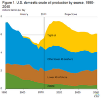
The United States is well on its way to energy independence, with the Obama administration announcing Wednesday that domestic oil production surpassed imports for the first time in nearly two decades. A report by the U.S. Energy Information Administration (EIA) offers proof that the United States has managed both to increase domestic oil and gas drilling and reduce the nation’s carbon emissions, which have dropped to a 20-year low. Since 2008, U.S. crude oil output has increased 50 percent, while imports have fallen about 20 percent.
-
-
The Philippines is victim of geography, poor infrastructure, poverty
Owing to its location and geography, the Philippines is one of the most natural disaster-prone countries in the world. On average the country experiences nine major typhoons and 900 earthquakes annually, and it has twenty-five active volcanoes. Poor infrastructure and pervasive poverty exacerbate the impact of disasters, making them even more deadly and destructive. “In a cruel cycle, poverty and underdevelopment make disasters worse, and disasters make poverty and underdevelopment worse,” one observer notes.
-
-
Past as prologue: Insights from past natural disasters relevant today
The increasing frequency and intensity of natural disasters constitute a daunting challenge to modern society, which is characterized by a heavy infrastructure and increasing population density. Until now, coping with natural disasters has involved expensive state intervention and technology-aided approaches, but researchers believes that the past contains a wealth of unexploited resources which could also provide solutions to the problems communities face when dealing with need to cope with, and recover from, natural disasters.
-
-
Climate scientists say renewables are not enough
Some of the world’s top climatologists have declared their support for nuclear energy as a complementary energy source, alongside wind and solar as energy, which would cut fossil fuel pollution and reduce the growth of global warming. The scientists say that opposing fossil fuels and promoting renewable energy sources offer but a limited solution.
-
-
Philippines prepares for worse disasters to come
On average, the Philippines experiences about twenty typhoons a year, including three super-typhoons and many incidents of flooding, drought, earthquakes, tremors, and occasional volcanic eruptions, making the country one of the most naturally disaster-prone areas in the world. Filipino government agencies, with the help of international disaster and relief agencies, have created new strategies for disaster preparedness, response, and mitigation which may well have potential applications in other parts of the world. As the impact of climate change grows more pronounced, the Philippines is becoming a hothouse for developing new methods and systems in the growing business of disaster relief.
-
-
Sunlight-activated nanogrid breaks down pollutants in water
Oil spills do untold damage to the environment — to the waters they pollute and to marine and other wildlife. The Deepwater Horizon spill in the Gulf of Mexico in 2010, for example, the largest accidental marine oil spill in the history of the petroleum industry, flowed unabated for three months. Typically, such oil spills are extraordinarily difficult to clean up. Soon, however, the process may become infinitely easier and ecologically friendly, the result of a new invention — “nanogrid” — a large net consisting of metal grids made of a copper tungsten oxide, that, when activated by sunlight, can break down oil from a spill, leaving only biodegradable compounds behind.
-
-
Chelyabinsk meteor explosion a "wake-up call," scientists warn
Three new studies have revealed details of the meteor that exploded above Russian city, Chelyabinsk, in February this year. Their findings provide information about the meteor’s origin, trajectory, power and damage by the airburst (the shock wave that travelled through the air from the explosion). These findings may help to refine theoretical models about the likely frequency of such events, the potential damage they could cause and hazard mitigation strategies needed for planetary protection.
-
-
Wildfire science returns to California’s Rim Fire
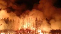
The challenging job of managing wildfires rests with other agencies, but the U.S. Geological Survey (USGS) provides the underlying science for sound land management decisions, before, during, and after wildfires. The USGS role studying natural hazards such as floods, landslides, earthquakes, and volcanoes is well known, but fewer people are aware of the USGS scientific work in major wildfire events, which are one of the most regular and sometimes most devastating natural hazards in the West.
-
-
Safe long-term CO2 storage possible
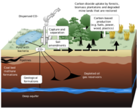
Since 2004, the German Research Centre for Geosciences (GFZ) has led an international research network to investigate the geological storage of the greenhouse gas (CCS, for carbon capture and storage). GFZ’s scientists say that their work at the Ketzin site, 40 km west of Berlin, has shown that geological CO2 storage on a pilot scale can be done safely and reliably.
-
-
Scientists: we should prepare for hell and high water
An international team of climate and social scientists say a new approach to climate preparedness is essential to help people adjust to coming changes. As climate-driven changes get more pronounced, people everywhere will have to adjust. In this week’s issue of the journal Science, an international group of researchers urge the development of science needed to manage climate risks and capitalize on unexpected opportunities.
-
-
Reducing volume of nuclear waste by 90 percent possible
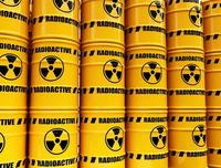
Engineers have developed a way significantly to reduce the volume of some higher activity wastes, which will reduce the cost of interim storage and final disposal. The researchers have shown that mixing plutonium-contaminated waste with blast furnace slag and turning it into glass reduces its volume by 85-95 percent. It also effectively locks in the radioactive plutonium, creating a stable end product.
-
- All
- Regional
- Water
- Biometrics
- Borders/Immig
- Business
- Cybersecurity
- Detection
- Disasters
- Government
- Infrastructure
- International
- Public health
- Public Safety
- Communication interoperabillity
- Emergency services
- Emergency medical services
- Fire
- First response
- IEDs
- Law Enforcement
- Law Enforcement Technology
- Military technology
- Nonlethal weapons
- Nuclear weapons
- Personal protection equipment
- Police
- Notification /alert systems
- Situational awareness
- Weapons systems
- Sci-Tech
- Sector Reports
- Surveillance
- Transportation
Advertising & Marketing: advertise@newswirepubs.com
Editorial: editor@newswirepubs.com
General: info@newswirepubs.com
2010-2011 © News Wire Publications, LLC News Wire Publications, LLC
220 Old Country Road | Suite 200 | Mineola | New York | 11501
Permissions and Policies
Editorial: editor@newswirepubs.com
General: info@newswirepubs.com
2010-2011 © News Wire Publications, LLC News Wire Publications, LLC
220 Old Country Road | Suite 200 | Mineola | New York | 11501
Permissions and Policies