-
No funds for California's earthquake early-warning system in Trump's proposed budget
The Trump administration’s proposed budget would eliminate federal funding for an earthquake early warning system being developed for the U.S. West Coast. Critics say that if the relevant clauses in the budget proposal become law, the long-planned seismic warning effort will be killed. Scientists say the withdrawal of federal funds would likely end the early-warning project, which aims to send smartphone tremor alert messages to West Coast residents.
-
-
Israel to install earthquake early-warning system
Israel has selected Ottawa, Canada-based Nanometrics to build an earthquake early-warning system in Israel. The alert system will give a 10-to-30-second alert of an impending earthquake. The system’s success depends on the distinction between two types of waves an earthquake generates — P waves (for primary) and S waves (for secondary). P waves are very fast, traveling through rock at between four and seven kilometers per second, and are thus the first waves to arrive at a recording station following an earthquake. An S-wave has a shearing motion that makes the rock vibrate perpendicular to its path. This movement slows the S-wave, so that it travels at two to five kilometers per second, or about half the speed of the P-wave. It is S waves which are almost entirely responsible for the damage and destruction associated with earthquakes.
-
-
Drones help in better understanding of wildfires
U.S. Geological Survey scientists and partners are taking technology to the next level, using unmanned aircraft systems (UAS) to acquire both fire intensity and emissions data during prescribed burns. This effort combines expertise from multiple USGS partners that could reduce the harmful effects of smoke impacts from use of prescribed burns. Lessening the risk to property and lives during wildfires is a primary purpose of prescribed burns.
-
-
Knowing more and loosing less: Science and helps in disaster risk management
Natural and man-made disasters threaten millions of people every year and cause billions of property damage. How much do we know about them? And how can we use that knowledge to save lives and money? A recent report —Science for Disaster Risk Management 2017: Knowing More and Losing Less — seeks to answer these and other questions and to help prepare for the time when disaster strikes.
-
-
Weather disaster-prone countries do not spend more on weather services
Countries hit hardest by weather-related disasters do not necessarily spend more on commercial weather and climate information services that assist in preparing for these events, a new study finds. Identifying countries for which this is true and improving the design and delivery of weather and climate services in these locations could lead to better decision-making regarding risks and challenges, ultimately helping to save lives, protect infrastructure, and move people out of poverty.
-
-
Climate change likely to increase risk of costly storms in U.K.
The impact of climate change on the United Kingdom is likely to mean a higher number of more expensive wind storms, the insurance industry warned. New analysis done for the Association of British Insurers (ABI) shows temperature increases of just a small number of degrees are likely to lead to insurance losses for high winds which could be 11 percent, 23 percent, or even 25 percent higher nationwide.
-
-
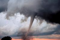
Tornado’s strength explains number of casualties more than number of people in twister’s way
New research shows that the strength of a tornado has a significantly larger effect than population on the number of casualties. Using a regression model, researchers found that on average a doubling of the population under the path of a tornado leads to a 21 percent increase in the casualty rate, while a doubling of the energy dispersed by the tornado leads to a 33 percent increase in the casualty rate.
-
-
Creating high-speed internet lane for emergency situations
In a disaster, a delay can mean the difference between life and death. Emergency responders don’t have time to wait in traffic — even on the congested information superhighway. Researchers are developing a faster and more reliable way to send and receive large amounts of data through the internet. By a creating a new network protocol, called Multi Node Label Routing protocol, researchers are essentially developing a new high-speed lane of online traffic, specifically for emergency information.
-
-
AI to aid in humanitarian efforts
Mobile phones are one of the fastest growing technologies in the developing world with global penetration rates reaching 90 percent. However, the fact that most phones in developing countries are pre-paid means that the data lacks key information about the person carrying the phone, including gender and other demographic data, which could be useful in a crisis. Researchers have developed an AI algorithm to accurately predict the gender of pre-paid mobile phone users, so that emergency response teams would have better information about those affected by disasters.
-
-
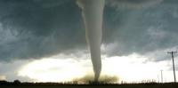
Tornado damage impact could triple in coming decades
Tornadoes are one of the most unpredictable weather phenomena on Earth. Each year the United States, home to more tornadoes than any other country, sustains billions of dollars of damage, death, injuries, and disruption from the violent storms. Scientists say that the potential for annual tornado impact magnitude and disaster could triple by the end of the twenty-first century.
-
-
New tool could help predict, prevent surging waters in flood plains
A group of international scientists studying China’s Yellow River has created a new tool that could help officials better predict and prevent its all-too-frequent floods, which threaten as many as eighty million people. The tool — a formula to calculate sediment transport — may also be applied to studying the sustainability of eroding coastlines worldwide.
-
-
Tipping points: When natural or social systems reach a point of no return
A tipping point is a critical threshold at which a dynamical system undergoes an irreversible transformation, typically owing to a small change in inputs or parameters. This concept is very broad and can refer to the extinction of an animal or a plant species, the depletion of a water source, or the financial collapse of an institution, among many other natural and social phenomena. Researchers provide a better understanding of the characteristics of this point of no return and what happens to a system after its occurrence.
-
-
Helping power utilities and others better plan for the future
If you’re an electric utility planning a new power plant by a river, it would be nice to know what that river will look like twenty years down the road. Will it be so high that it might flood the new facility? Will the water be so low that it can’t be used to cool the plant? Generally, such projections have been based on records of past precipitation, temperature, flooding and other historical data. But in an era when temperature and precipitation are changing rapidly, historical patterns won’t do you much good. A new initiative by the U.S. Department of Energy’s (DOE) Argonne National Laboratory combines climate data and analysis with infrastructure planning and decision support, promises real help.
-
-
Wastewater injection rates triggered Oklahoma's largest earthquake
The 3 September 2016 magnitude 5.8 Pawnee quake, felt widely across Oklahoma, is the largest earthquake recorded in the state since the 1950s. Most Oklahoma earthquakes since 2009 are thought to have been triggered by wastewater produced by oil and gas drilling that has been injected back into the ground – and a new report says that changes to the rate of wastewater injection in disposal wells may have contributed to conditions that led to the Pawnee earthquake.
-
-
Radar simulator helps characterize scattering of debris in tornadoes
Researchers have developed the first numerical polarimetric radar simulator to study and characterize the scattering of debris particles in tornadoes. “An improved understanding of what weather radars tell us about tornado debris can help provide more accurate tornado warnings and quickly direct emergency personnel to affected areas,” says one researcher.
-
- All
- Regional
- Water
- Biometrics
- Borders/Immig
- Business
- Cybersecurity
- Detection
- Disasters
- Government
- Infrastructure
- International
- Public health
- Public Safety
- Communication interoperabillity
- Emergency services
- Emergency medical services
- Fire
- First response
- IEDs
- Law Enforcement
- Law Enforcement Technology
- Military technology
- Nonlethal weapons
- Nuclear weapons
- Personal protection equipment
- Police
- Notification /alert systems
- Situational awareness
- Weapons systems
- Sci-Tech
- Sector Reports
- Surveillance
- Transportation
Advertising & Marketing: advertise@newswirepubs.com
Editorial: editor@newswirepubs.com
General: info@newswirepubs.com
2010-2011 © News Wire Publications, LLC News Wire Publications, LLC
220 Old Country Road | Suite 200 | Mineola | New York | 11501
Permissions and Policies
Editorial: editor@newswirepubs.com
General: info@newswirepubs.com
2010-2011 © News Wire Publications, LLC News Wire Publications, LLC
220 Old Country Road | Suite 200 | Mineola | New York | 11501
Permissions and Policies