-
Ranking hazardous asteroid effects from least to most destructive

If an asteroid struck Earth, which of its effects—scorching heat, flying debris, towering tsunamis—would claim the most lives? A new study has the answer: violent winds and shock waves are the most dangerous effects produced by Earth-impacting asteroids. The study explored seven effects associated with asteroid impacts—heat, pressure shock waves, flying debris, tsunamis, wind blasts, seismic shaking and cratering—and estimated their lethality for varying sizes. Overall, wind blasts and shock waves were likely to claim the most casualties, with experimental scenarios showing that these two effects accounted for more than 60 percent of lives lost.
-
-
Big data study of disaster-related social media language helps first responders
Researchers explore how the properties of language style used in social media — particularly on Twitter — can help first responders quickly identify areas of need during a disaster. The researchers analyzed several hundred thousand tweets from social media users located in and around the areas where Hurricane Sandy, the Oklahoma tornadoes, and the Boston Marathon bombing occurred.
-
-
Mexico implements lessons from 1985 devastating earthquake
Five years after the devastating 1985 quake, which killed more than 10,000 people, Mexico equipped itself with one of the world’s most effective early warning systems for earthquakes. SASMEX: The Seismic Alert System of Mexico comprises more than 8200 seismic sensors located in the most active earthquake zone that runs between Jalisco, Michoacán, Guerrero, Oaxaca, and Mexico City.
-
-
New era of western wildfire requires new ways of protecting people, ecosystems
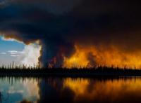
Current wildfire policy cannot adequately protect people, homes, and ecosystems from the longer, hotter fire seasons climate change is causing. Efforts to extinguish every blaze and reduce the buildup of dead wood and forest undergrowth are becoming increasingly inadequate on their own. Instead, experts urge policymakers and communities to embrace policy reform that will promote adaptation to increasing wildfire and warming.
-
-
Latest science on sea level rise projections: In support of California policy guidance
An estimated 75 percent of California’s population lives in coastal counties. Sea-level rise, already underway, threatens hundreds of miles of roads and railways, harbors, airports, power plants, wastewater treatment plants, coastal wetlands, beaches, dunes, bluffs, and thousands of businesses and homes. In a comprehensive analysis of the factors that affect how much the ocean will rise along California’s coast in coming decades, a seven-member team of experts has provided the state with a report on the best-available sea-level rise science — including recent scientific advances on the role of polar ice loss.
-
-
Cities inland could be reshaped by migration from sea-level rise
When Hurricane Katrina struck Louisiana in 2005, cities inland saw an influx of evacuees escaping the storm and its aftermath. Now, a new study predicts that this could happen again as a result of sea-level rise. Researchers estimate that approximately 13.1 million people could be displaced by rising ocean waters, with Atlanta, Houston, and Phoenix as top destinations for those forced to relocate. The study is the first attempt to model the destination of millions of potentially displaced migrants from heavily populated coastal communities.
-
-
Asteroid to fly by Earth on 19 April at a safe, but uncomfortably close, distance

An asteroid as big as the Rock of Gibraltar will streak past Earth on 19 April at a safe, but uncomfortably close, distance. Although there is no possibility for the asteroid to collide with our planet, this will be a very close approach for an asteroid of this size. The encounter on 19 April is the closest this asteroid has come to Earth for at least the last 400 years and will be its closest approach for at least the next 500 years.
-
-
In West Africa, investment key in adapting to climate change
Climate change will likely have negative impacts on food production in West Africa, with crop yields and grass for livestock grazing likely to decline in the future. A new study provides insights on how strategic planning by decision makers could ease or exacerbate food security challenges in the region.
-
-
New resilience study helps governments prevent disaster-related loss
Hurricanes, wildfires, tsunamis, and other disasters cannot be stopped, but countries can plan for them — something some areas of the world seem to do better than others, according to a new study. In the study, thirty-eight factors that affect a country’s resilience were derived from national and international databases, and the researchers used these databases to grade the resilience of each country and continent and develop a comprehensive index that includes indicators such as the number of disasters and their death tolls, as well as an area’s population, infrastructure, economy and educational system.
-
-
Harsh U.S. weather in March expected to cost insurers more than $2 billion
An extremely active period for severe weather persisted in the United States throughout March, as four separate significant outbreaks led to extensive damage in central and eastern parts of the country. The most prolific outbreak from 6 to 10 March resulted in major damage from tornadoes, large hail, and straight-line winds in the Plains, Midwest, and Southeast. Total economic losses for this event alone were estimated at $1.7 billion, while public and private insurance claims were listed at $1.2 billion. The aggregated cost to the insurance industry from the four events was expected to exceed $2.0 billion.
-
-
Earthquake early warning vital for city transit
Although no one can reliably predict earthquakes, today’s technology is advanced enough to rapidly detect seismic waves as an earthquake begins, calculate the maximum expected shaking, and send alerts to surrounding areas before damage can occur. This technology is known as “earthquake early warning” (EEW). An EEW system called “ShakeAlert” is being developed and tested for the West Coast of the United States.
-
-
New layer of defense against earthquakes, tsunamis
The first computer model to simulate the whole chain of hazard events triggered by offshore mega subduction earthquakes could reduce losses to life and property caused by disasters like the huge earthquake and tsunami that struck Japan six years ago. The model, designed to be used in any part of the world potentially vulnerable to offshore subduction earthquakes (where one tectonic plate is forced beneath another), integrates every aspect of an undersea earthquake - including tsunamis, aftershocks and landslides - into a single disaster simulation tool.
-
-
Future CO2 levels, climate warming unprecedented in 420 million years
New research suggests that, over the next 100 to 200 years, carbon dioxide concentrations in the Earth’s atmosphere will head towards values not seen since the Triassic period, 200 million years ago. Furthermore, by the twenty-third century, the climate could reach a warmth not seen in 420 million years.
-
-
Rising flood insurance costs a growing burden to communities, NYC homeowners
Flood insurance is already difficult to afford for many homeowners in New York City, and the situation will only worsen as flood maps are revised to reflect current risk and if the federal government continues to move toward risk-based rates, according to a new study.of-its-kind study by the RAND Corporation.
-
-
Seismic monitoring network helps locate, determine origins of earthquakes in Texas
Almost a decade ago, the ground around the densely populated Dallas-Fort Worth Metroplex started shaking. As the frequency and intensity of earthquakes increased in a region poorly prepared for the seismic activity, the risk became a priority for the state. Residents, politicians, and oil-gas industry leaders reached out to the Bureau of Economic Geology. The bureau is the oldest and second largest research unit at the university, made up of more than 250 scientists, engineers, and economists. The organization also functions as the State Geological Survey of Texas — a broker of information among industry, academia and government agencies.
-
- All
- Regional
- Water
- Biometrics
- Borders/Immig
- Business
- Cybersecurity
- Detection
- Disasters
- Government
- Infrastructure
- International
- Public health
- Public Safety
- Communication interoperabillity
- Emergency services
- Emergency medical services
- Fire
- First response
- IEDs
- Law Enforcement
- Law Enforcement Technology
- Military technology
- Nonlethal weapons
- Nuclear weapons
- Personal protection equipment
- Police
- Notification /alert systems
- Situational awareness
- Weapons systems
- Sci-Tech
- Sector Reports
- Surveillance
- Transportation
Advertising & Marketing: advertise@newswirepubs.com
Editorial: editor@newswirepubs.com
General: info@newswirepubs.com
2010-2011 © News Wire Publications, LLC News Wire Publications, LLC
220 Old Country Road | Suite 200 | Mineola | New York | 11501
Permissions and Policies
Editorial: editor@newswirepubs.com
General: info@newswirepubs.com
2010-2011 © News Wire Publications, LLC News Wire Publications, LLC
220 Old Country Road | Suite 200 | Mineola | New York | 11501
Permissions and Policies