-
Short-lived greenhouse gases cause centuries of sea-level rise
Even if there comes a day when the world completely stops emitting greenhouse gases into the atmosphere, coastal regions and island nations will continue to experience rising sea levels for centuries afterward, according to a new study. Researchers report that warming from short-lived compounds — greenhouse gases such as methane, chlorofluorocarbons, or hydrofluorocarbons, that linger in the atmosphere for just a year to a few decades — can cause sea levels to rise for hundreds of years after the pollutants have been cleared from the atmosphere.
-
-
More frequent large-scale tornado outbreaks
The frequency of large-scale tornado outbreaks is increasing in the United States, particularly when it comes to the most extreme events, according to new research. The researchers found that the increase in tornado outbreaks does not appear to be the result of a warming climate as earlier models suggested. Instead, their findings tie the growth in frequency to trends in the vertical wind shear found in certain supercells—a change not so far associated with a warmer climate.
-
-
More rainfall in a warmer world will likely intensify typhoons in the western Pacific
An analysis of the strongest tropical storms, known as super typhoons, in the western Pacific over the last half-century reveals that they are intensifying. Higher global temperatures have enhanced global rainfall, particularly over the tropical oceans. Rain that falls on the ocean reduces salinity and allows typhoons to grow stronger. Salty ocean water normally mellows typhoons, but more rainfall interferes with that safety valve.
-
-
Estimating frequency of volcanic eruptions
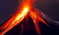
The 2010 explosive eruption of Icelandic volcano Eyjafjallajökull, which caused more than ten million air passengers to be stranded and cost the European economy an estimated $6 billion. Holidaymakers concerned about fresh volcanic eruptions causing flight-disrupting ash clouds might be reassured by a study setting out the first reliable estimates of their frequency.
-
-
Flood risks changing across U.S.
The risk of flooding in the United States is changing regionally, and the reasons could be shifting rainfall patterns and the amount of water in the ground. Engineers determined that, in general, the threat of flooding is growing in the northern half of the U.S. and declining in the southern half. The American Southwest and West, meanwhile, are experiencing decreasing flood risk.
-
-
Assessing climate resiliency of more than 250 U.S. cities
The University of Notre Dame’s Global Adaptation Initiative (ND-GAIN) has announced it will assess the climate vulnerability and readiness of every U.S. city with a population over 100,000 — more than 250 in all — in an effort to help inform decisions by city officials on infrastructure, land use, water resources management, transportation and other adaptive strategies. The Urban Adaptation Assessment (UAA) will also integrate a social equity analysis, which will investigate how vulnerable groups are disproportionately harmed by climate hazards, such as extreme heat, flooding and extreme cold.
-
-
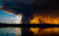
Devastating wildfires in Eastern forests likely to be repeated
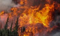
The intense wildfires that swept through the Smoky Mountains in Tennessee late last month were a tragic melding of the past and the future. The fast-moving, wind-whipped blazes that burned more than 150,000 acres, killed fourteen people and damaged 2,400 structures in Gatlinburg and Sevier County may be a portent of things to come.
-
-
Quake-detection app recorded nearly 400 temblors worldwide
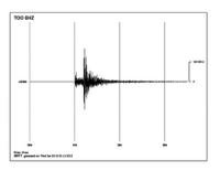
UC Berkeley’s worldwide network of smartphone earthquake detectors has recorded nearly 400 earthquakes since the MyShake app was made available for download in February, with one of the most active areas of the world the fracking fields of Oklahoma. The Android app harnesses a smartphone’s motion detectors to measure earthquake ground motion, then sends that data back to the Berkeley Seismological Laboratory for analysis. The eventual goal is to send early-warning alerts to users a bit farther from ground zero, giving them seconds to a minute of warning that the ground will start shaking.
-
-
The origins of Tennessee’s recent wildfires
Wildfires raged recently through the foothills of Tennessee’s Great Smoky Mountains, fueled by severe drought and high winds in the eastern part of the state. The fires damaged or destroyed more than 1,400 structures, including homes, chapels, and resort cabins. Fourteen people were killed, and nearly 150 others were injured. Last week, two juveniles were taken into custody and charged with aggravated arson in connection with the deadly wildfires – but sources such as Climate Central suggested that rising temperatures may have played a role in the fires. Does climate change play a role in determining the frequency and intensity of wildfires?
-
-
New approach calculates benefits of building hazard-resistant structures
The southeastern United States was hit hard by weather patterns resulting from Hurricane Matthew in October. Georgia has sustained some $90 million in insured losses to date, and total claims are expected to rise. Florida was spared Matthew’s worst effects, but the state is regularly witness to the destructive power of such storms and there’s a lot at stake: The insured value of residential and commercial properties in Florida’s coastal counties now exceeds $13 trillion. Calculation developed by MIT Concrete Sustainability Hub shows that when building in areas prone to natural disasters, it pays to make informed decisions.
-
-
Improving methods to assess earthquake-caused soil liquefaction
Several strong earthquakes around the world have resulted in a phenomenon called soil liquefaction, the seismic generation of excess porewater pressures and softening of granular soils, often to the point that they may not be able to support the foundations of buildings and other infrastructure. Effectively engineering infrastructure to protect life and to mitigate the economic, environmental, and social impacts of liquefaction requires the ability to accurately assess the likelihood of liquefaction and its consequences.
-
-
Dust Bowl would devastate today’s crops: Study
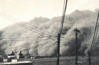
A drought on the scale of the legendary Dust Bowl crisis of the 1930s would have similarly destructive effects on U.S. agriculture today, despite technological and agricultural advances, a new study finds. Additionally, warming temperatures could lead to crop losses at the scale of the Dust Bowl, even in normal precipitation years by the mid-twenty first century.
-
-
May 2012 North Korean seismic event an earthquake, not nuclear test
A tiny seismic event that occurred in North Korea on 12 May 2010 appears to have been an earthquake rather than a small underground nuclear explosion, according to a new analysis. The new study contradicts the findings of a 2015 report which concluded that the magnitude 1.5 seismic 12 May event was a small nuclear explosion.
-
-
Freezing in record lows may raise doubts about global warming
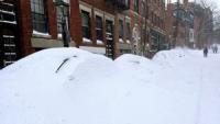
If you are shivering from unusually teeth-rattling cold this holiday season, global warming is probably the last thing on your mind. “The local weather conditions people experience likely play a role in what they think about the broader climate,” says one expert. “Climate change is causing record-breaking heat around the world, but the variability of the climate means that some places are still reaching record-breaking cold. If you’re living in a place where there’s been more record cold weather than record heat lately, you may doubt reports of climate change.”
-
-
Accelerating sea level rise requires collaborative response: Experts
Recent estimates suggest that global mean sea level rise could exceed two meters by 2100. The projections pose a challenge for scientists and policymakers alike, requiring far-reaching decisions about coastal policies to be made based on rapidly evolving projections with large, persistent uncertainties. Policymakers and scientists must thus act quickly and collaboratively to help coastal areas better prepare for rising sea levels globally, say climate change experts.
-
- All
- Regional
- Water
- Biometrics
- Borders/Immig
- Business
- Cybersecurity
- Detection
- Disasters
- Government
- Infrastructure
- International
- Public health
- Public Safety
- Communication interoperabillity
- Emergency services
- Emergency medical services
- Fire
- First response
- IEDs
- Law Enforcement
- Law Enforcement Technology
- Military technology
- Nonlethal weapons
- Nuclear weapons
- Personal protection equipment
- Police
- Notification /alert systems
- Situational awareness
- Weapons systems
- Sci-Tech
- Sector Reports
- Surveillance
- Transportation
Advertising & Marketing: advertise@newswirepubs.com
Editorial: editor@newswirepubs.com
General: info@newswirepubs.com
2010-2011 © News Wire Publications, LLC News Wire Publications, LLC
220 Old Country Road | Suite 200 | Mineola | New York | 11501
Permissions and Policies
Editorial: editor@newswirepubs.com
General: info@newswirepubs.com
2010-2011 © News Wire Publications, LLC News Wire Publications, LLC
220 Old Country Road | Suite 200 | Mineola | New York | 11501
Permissions and Policies