-
Humans have dramatically increased extent, duration of U.S. wildfire season
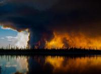
The United States has experienced some of its largest wildfires on record over the past decade, especially in the western half of the country. The duration and intensity of future wildfire seasons is a point of national concern given the potentially severe impact on agriculture, ecosystems, recreation, and other economic sectors, as well as the high cost of extinguishing blazes. The annual cost of fighting wildfires in the United States has exceeded $2 billion in recent years. Humans have dramatically increased the spatial and seasonal extent of wildfires across the United States in recent decades and ignited more than 840,000 blazes in the spring, fall and winter seasons over a 21-year period, according to a new study.
-
-
Significant chance of earthquake damage in Central, Eastern U.S.: USGS
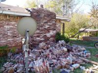
A one-year seismic hazard model for 2017, from the U.S. Geological Survey, forecasts lower damaging ground shaking levels in the central and eastern United States compared to the previous forecast, in areas where there have been numerous earthquakes induced by wastewater disposal from industrial activities – but despite the recent drop in earthquake rates, Oklahoma and southern Kansas still face a significant risk of induced earthquake damage in 2017.
-
-
Calculating climate change losses in major European coastal cities
A new study that assesses potential future climate damage to major European coastal cities has found that, if, as currently, global carbon emissions continue to track the Intergovernmental Panel on Climate Change’s worst emission scenario (RCP8.5), overall annual economic losses may range from $1.2 billion in 2030 to more than $40 billion by 2100. The study focused on nineteen major European coastal cities including Istanbul, Rotterdam, Barcelona, Hamburg, London, Dublin, Marseille, St Petersburg, and Copenhagen.
-
-
Tsunami pod to the rescue
What if you are a coastal dweller and you hear a tsunami warning – but you have no way, or no time, to run for high ground before the wave hits. What if there are no tall, sturdy buildings nearby? Mukilteo, Washington-based Survival-Capsule has a solution: A tsunami pod. The Survival Capsule is a patent-pending, personal safety system (PSS) is a spherical ball to protect against tsunami events, tornadoes, hurricanes, earthquakes, and storm surges.
-
-
Recovery lessons from Hurricane Sandy to help improve resilience, disaster preparedness
Purdue University will lead a $2.5 million, four-year research to determine why some communities recover from natural disasters more quickly than others, an effort aimed at addressing the nation’s critical need for more resilient infrastructure and to enhance preparedness. The research team will apply advanced simulations and game-theory algorithms, access millions of social media posts and survey data collected along the New Jersey shore, which was devastated by Hurricane Sandy in 2012.
-
-
As climate warms, Colorado River flows will keep shrinking
Warming in the twenty-first century reduced Colorado River flows by at least 0.5 million acre-feet, about the amount of water used by two million people for one year. From 2000 to 2014, the river’s flows declined to only 81 percent of the twentieth-century average, a reduction of about 2.9 million acre-feet of water per year. One acre-foot of water will serve a family of four for one year, according to the U.S. Bureau of Reclamation. From one-sixth to one-half of the twenty-first-century reduction in flow can be attributed to the higher temperatures since 2000. As temperature continues to increase with climate change, Colorado River flows will continue to decline.
-
-
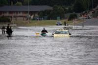
Over time, nuisance flooding can cost more than extreme, infrequent events
Global climate change is being felt in many coastal communities of the United States, not always in the form of big weather disasters but as a steady drip, drip, drip of nuisance flooding. Rising sea levels will cause these smaller events to become increasingly frequent in the future, and the cumulative effect will be comparable to extreme events such as Hurricane Katrina or Superstorm Sandy.
-
-
New climate model predicts likelihood of Greenland ice melt, sea level rise, dangerous temperatures
A new computer model of accumulated carbon emissions predicts the likelihood of crossing several dangerous climate change thresholds. These include global temperature rise sufficient to lose the Greenland Ice Sheet and generate seven meters of long-term sea level rise, or tropical region warming to a level that is deadly to humans and other mammals.
-
-
Improving climate change modeling by including variables such as inequality, consumption, and population
A new scientific paper by an international team of distinguished scientists, including five members of the National Academies, argues that there are critical two-way feedbacks missing from current climate models that are used to inform environmental, climate, and economic policies. The most important inadequately modeled variables are inequality, consumption, and population. The authors present extensive evidence of the need for a new paradigm of modeling that incorporates the feedbacks that the Earth System has on humans, and propose a framework for future modeling that would serve as a more realistic guide for policymaking and sustainable development.
-
-
Sea-level rise in Southeast Asia 6,000 years ago relevant for coastal dwellers today
For the 100 million people who live within three feet of sea level in East and Southeast Asia, the news that sea level in their region fluctuated wildly more than 6,000 years ago is important, according to researchers. This is because those fluctuations occurred without the assistance of human-influenced climate change. Such a change in sea level could happen again now, on top of the rise in sea level that is already projected to result from climate change. This could be catastrophic for people living so close to the sea.
-
-
Last year’s El Niño resulted in unprecedented erosion of the Pacific coastline
Last winter’s El Niño might have felt weak to residents of Southern California, but it was in fact one of the most powerful climate events of the past 145 years. If such severe El Niño events become more common in the future as some studies suggest they might, the California coast — home to more than twenty-five million people — may become increasingly vulnerable to coastal hazards. And that’s independent of projected sea level rise.
-
-
Humans now affect Earth system more than natural forces
Humans are causing the climate to change 170 times faster than natural forces, new research finds. The study for the first time came up with a mathematical equation to describe the impact of human activity on the Earth system, known as the Anthropocene equation. Over the past 7,000 years the primary forces driving change have been astronomical — driving a rate of change of 0.01 degrees Celsius per century. “Human-caused greenhouse gas emissions over the past forty-five years have increased the rate of temperature rise to 1.7 degrees Celsius per century, dwarfing the natural background rate,” the researchers say.
-
-
Trend: Americans building “doomsday bunkers” in large numbers
It may be a fad of the moment, or an indication of a deeper trend, but people across the United States are building and buying “doomsday bunkers” in large numbers. It is not exactly a new business, but demand for underground bunkers is at an all-time high according to industry insiders. A Texas bunker company saw its sales increase 400 percent in the past two months.
-
-
World leaders urged to take action to avert existential global risks
World leaders must do more to limit risk of global catastrophes, according to a report by Oxford academics. He academic define global catastrophe as a risk “where an adverse outcome would either annihilate Earth-originating intelligent life or permanently and drastically curtail its potential.” Three of the most pressing possible existential risks for humanity are pandemics, extreme climate change, and nuclear war.
-
-
Current climate change models understate the problem
A new study on the relationship between people and the planet shows that climate change is only one of many inter-related threats to the Earth’s capacity to support human life. An international team of distinguished scientists, including five members of the National Academies, argues that there are critical components missing from current climate models that inform environmental, climate, and economic policies.
-
- All
- Regional
- Water
- Biometrics
- Borders/Immig
- Business
- Cybersecurity
- Detection
- Disasters
- Government
- Infrastructure
- International
- Public health
- Public Safety
- Communication interoperabillity
- Emergency services
- Emergency medical services
- Fire
- First response
- IEDs
- Law Enforcement
- Law Enforcement Technology
- Military technology
- Nonlethal weapons
- Nuclear weapons
- Personal protection equipment
- Police
- Notification /alert systems
- Situational awareness
- Weapons systems
- Sci-Tech
- Sector Reports
- Surveillance
- Transportation
Advertising & Marketing: advertise@newswirepubs.com
Editorial: editor@newswirepubs.com
General: info@newswirepubs.com
2010-2011 © News Wire Publications, LLC News Wire Publications, LLC
220 Old Country Road | Suite 200 | Mineola | New York | 11501
Permissions and Policies
Editorial: editor@newswirepubs.com
General: info@newswirepubs.com
2010-2011 © News Wire Publications, LLC News Wire Publications, LLC
220 Old Country Road | Suite 200 | Mineola | New York | 11501
Permissions and Policies