-
Cost of flood losses in major coastal cities to exceed $50 billion by 2050
A new study estimate present and future flood losses — or the global cost of flooding — in 136 of the world’s largest coastal cities, taking into account existing coastal protections. Average global flood losses in 2005, estimated at about $6 billion per year, could increase to $52 billion by 2050 with projected socio-economic change alone. Due to their high wealth and low protection level, three American cities — Miami, New York City, and New Orleans — are responsible for 31 percent of the losses across the 136 cities.
-
-
Investigating earthquake retrofits for “soft” first-floor buildings
A team of researchers has spent the last month shaking a four-story building on the world’s largest outdoor shake table at the University of California, San Diego, to learn how to make structures with first-floor garages better withstand seismic shocks. Since July, the team has successfully tested a variety of earthquake retrofits on a full-scale, 44,000-square-foot building built specifically for the tests at the Englekirk Structural Engineering Center at UCSD. The structure — three stories atop an open first floor — has survived three of four simulated seismic events of increasing strength on the shake table.
-
-
Artists join scientists to plot disaster scenarios
Researchers investigate how human and software agents can effectively work together to collect the best possible information from a disaster environment. The researchers have been exploring the use of unmanned autonomous systems (UAS) fitted with audio-visual equipment that can improve the response of emergency services and populations to disaster management. The team will be joined by two artists who will challenge the researchers to imagine new disaster scenarios that UAS technology may have to respond to.
-
-
Sandy shows need for more effective preparedness, resiliency standards
The rebuilding efforts following the devastation wreaked by Superstorm Sandy have triggered a discussion over preparedness and resiliency in America’s commercial and residential buildings.Some experts callfor a presidential appointment of a building resilience “’czar”’ with authority to coordinate and seek synergies between public and private sector initiatives.
-
-
Louisiana energy companies sued over destruction of New Orleans' wetlands
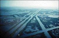
The Louisiana oil and gas industry has dredged more than 10,000 miles of canals through the state’s wetlands, causing the destruction of natural buffers and barriers which, in the past, had moderated the impact of hurricanes and protected New Orleans from severe storms. The Army Corps of Engineers has embarked on a $14.6 billion plan to undo some of the damage caused by the energy companies. The plan consists of levee improvement, wetland restoration, and land reclamation to make New Orleans better protected in the face of rising seas and more frequent and severe extreme weather events. The Southeast Louisiana Flood Protection Authority East (SLFPAE) has filed suit against 94energy companies,asking the court to order the companies to do their part to correct the problem they have caused.
-
-
Heat waves to become more frequent, severe
Climate change is set to trigger more frequent and severe heat waves in the next thirty years regardless of the amount of carbon dioxide (CO2) we emit into the atmosphere, a new study has shown. In the first half of the twenty-first century, these projections will occur regardless of the amount of CO2 emitted into the atmosphere. After then, the rise in frequency of extreme heat waves becomes dependent on the emission scenario adopted.
-
-
Monitoring slow earthquakes to predict larger events
Normal stick slip earthquakes typically move at a rate of three to 33 feet per second, but slow earthquakes, while they still stick and slip for movement, move at rates of about 0.004 inches per second, taking months or more to rupture. Slow earthquakes, however, often occur near traditional earthquake zones and may precipitate potentially devastating earthquakes. Monitoring slow earthquakes may thus provide a basis for reliable prediction in areas where slow quakes trigger normal earthquakes.
-
-
Climate change was proximate, not primary, cause of 2012 Great Plains drought: study

From May to July 2012, the Great Plains region of the western United States faced a powerful and unpredicted drought. Following seven months of normal rainfall, the drought was one of the largest deviations from seasonal precipitation rates seen in the region since observations began in 1895. Researches find that the drought fell within the bounds of natural atmospheric variability. The strength of the drought, they suggest, was a consequence of the multiple complex nonlinear systems that make up the climate system and did not critically depend on the existence of a strong external forcing.
-
-
Site of proposed Los Angeles skyscrapers may contain active seismic fault
Officials at New York-based Millennium Partners have agreed to dig a trench on a site proposed for two towers, thirty-nine and thirty-five stories tall, flanking the iconic Capitol Records building in Los Angeles. Opponents of the project say there is an active seismic fault under the planned location for the two towers, and the developer says the trench will allow geologists to see whether or not it would be safe to build the towers on the proposed site. Critics say that a panel of neutral experts, led by state officials, should do the geological investigation.
-
-
Better approach toward projecting, planning for rising sea levels on a warmer Earth
More useful projections of sea level are possible despite substantial uncertainty about the future behavior of massive ice sheets, according to Princeton University researchers. The researchers present a probabilistic assessment of the Antarctic contribution to twenty-first century sea-level change. Their methodology folds observed changes and models of different complexity into unified projections that can be updated with new information. This approach provides a consistent means to integrate the potential contribution of both continental ice sheets — Greenland and Antarctica — into sea-level rise projections.
-
-
Bolstering national grid resilience as extreme weather events intensify
Between 2003 and 2012, an estimated 679 widespread power outages in the United States occurred due to severe weather. A recent Congressional Research Service study estimates the inflation-adjusted cost of weather-related outages at $25 to $70 billion annually. A new White House report says that grid resilience is increasingly important as climate change increases the frequency and intensity of severe weather.
-
-
Guaranteeing communication coverage in the event of disaster
An EU-funded project that aims to develop a rapidly deployable wireless communication network for use in the aftermath of an emergency, disaster, or unexpected event, was commended recently at an international event.
-
-
A 34-story wooden skyscraper to be built in Stockholm
A Swedish architectural form is building a 34-story wood skyscraper in downtown Stockholm. Solid wood will be the predominant material in the building’s pillars and beams, while inside the apartments, walls, ceilings, fittings and window frames will be also constructed of wood.The firm says that wood is not only cheaper than either steel or concrete, but is also more fire resistant than both. This is due to 15 percent of wood mass being water, which will evaporate before the wood actually burns. In addition, logs get charred which protects the core.
-
-
Assessing the risks of global aftershock
The entire world becomes an aftershock zone after a massive magnitude (M) 7 or larger earthquake — but what hazard does this pose around the planet? Researchers are working to extend their earthquake risk estimates over a global scale, as they become better at forecasting the impact of aftershocks at a local and regional level.
-
-
Making storm warnings more exact, useful
The College of Staten Island (CSI)is the home of one of the most powerful mainframe computer systems in the country, an outgrowth of the City University of New York’s (CUNY) Decade of Science initiative. Following August 2011 Hurricane Irene, CSI scientistsset out to use that computing horsepower to generate scientific data hard enough to make the warnings something more than abstract. They fed millions of data points into the supercomputers, turning an admixture of geology, oceanography, climatology, and land surveys into a set of highly specific projections. Then, on 25 October 2012, Superstorm Sandy hit, and the actual water surges could be measured against the surge projections of the CSI model. On street after street, the computer model predicted flooding to within a foot of the actual surges.
-
- All
- Regional
- Water
- Biometrics
- Borders/Immig
- Business
- Cybersecurity
- Detection
- Disasters
- Government
- Infrastructure
- International
- Public health
- Public Safety
- Communication interoperabillity
- Emergency services
- Emergency medical services
- Fire
- First response
- IEDs
- Law Enforcement
- Law Enforcement Technology
- Military technology
- Nonlethal weapons
- Nuclear weapons
- Personal protection equipment
- Police
- Notification /alert systems
- Situational awareness
- Weapons systems
- Sci-Tech
- Sector Reports
- Surveillance
- Transportation
Advertising & Marketing: advertise@newswirepubs.com
Editorial: editor@newswirepubs.com
General: info@newswirepubs.com
2010-2011 © News Wire Publications, LLC News Wire Publications, LLC
220 Old Country Road | Suite 200 | Mineola | New York | 11501
Permissions and Policies
Editorial: editor@newswirepubs.com
General: info@newswirepubs.com
2010-2011 © News Wire Publications, LLC News Wire Publications, LLC
220 Old Country Road | Suite 200 | Mineola | New York | 11501
Permissions and Policies