ResilienceNew USGS models help predict storm effects on beaches
As the 2016 hurricane season opens, weather forecasters, emergency managers and coastal residents have access to tools developed by the USGS which predict, more precisely than ever, where beach erosion and beachfront flooding will take place during hurricanes and other storms.
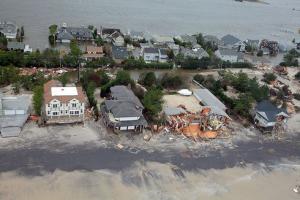
Beach and house damage by Hurricane Sandy // Source: commons.wikimedia.org
As the 2016 hurricane season opens, weather forecasters, emergency managers and coastal residents have access to tools developed by the U.S. Geological Survey (USGS) that predict, more precisely than ever, where beach erosion and beachfront flooding will take place during hurricanes and other storms. These potentially life-saving coastal change forecasts are publicly available online for beaches within a hurricane’s predicted strike zone approximately thirty-six hours before the storm makes landfall. USGS says that in a pilot program beginning this year, emergency managers and forecasters in areas of coastal Florida, North Carolina and Massachusetts will have access to hour-by-hour predictions of potential beachfront changes brought on by hurricanes, Nor’easters, or lesser storms.
“This year coastal residents can get specific information about likely impacts from an approaching storm, like where erosion will occur, whether sand dunes will be inundated by storm surge, and how high water levels are expected to be at the shoreline,” said USGS research oceanographer Hilary Stockdon, who led the development of these forecasting tools.
While most people think of hurricanes as massive wind and rain storms, “storm surge and large waves pose the greatest threat to life and property along the coast,” according to the National Hurricane Center’s hazards summary. Beaches are important natural barriers against damaging waves, but their capacity to protect coastal communities varies, depending on local coastal conditions and each storm’s characteristics.
The USGS’ coastal change forecast model works with information from the National Hurricane Center’s storm surge predictions and NOAA wave forecast models, which describe storm waves’ heights and the timing between them. The USGS model adds information about the beach slope and predicts how far a storm’s large waves will push water up the beach. “That allows us to predict whether water levels will overtop dunes, whether ocean water will inundate areas behind the beachfront, and whether barrier islands will breach,” said USGS research oceanographer Joseph Long, a member of the team working on the models.
In 2015 the USGS began providing emergency managers and citizens with detailed information from the coastal change forecast developed by Stockdon and others. The forecast provides information for Gulf and Atlantic sandy beaches every kilometer (just under two-thirds of a mile). When a hurricane is expected to strike the U.S. coast, the model shows three types of likely impacts - beach erosion, dune overwash and coastal inundation – for the predicted area of landfall. The USGS’ Coastal Change Hazards Portal makes that information easily accessible to the public when a storm is approaching. It also offers scenarios for those same three types of coastal change if hypothetical hurricanes ranging from Category 1 to Category 5 make landfall anywhere along the U.S. Atlantic or Gulf coasts.
A new version of the coastal change forecast model, which Long is developing and testing with the National Weather Service, can make the same types of predictions up and down the coast at a scale of 300 meters, or about two-tenths of a mile. It also runs continuously, so it can predict beach changes under all sorts of weather conditions, including on calm days.
USGS notes that along a frequently eroded or overwashed beach near Kitty Hawk, North Carolina, USGS and U.S. Army Corps of Engineers scientists are using two video cameras and a laser measuring device to field test and refine hourly predictions of a storm’s effects. During an April storm, the model predicted that waves could carry sand onto a beachfront road behind the dunes, Long said. The prediction was confirmed when the video cameras captured the overwash and sand covering the roadway as they happened.
To supplement the video cameras providing real-time information along the North Carolina beach, Long wants to install beach cameras on the northeast coast of Massachusetts, in Jupiter, Florida and on the Gulf of Mexico at Tampa Bay. A Tampa Bay camera is ready to go. The researchers are seeking a beachfront building whose owner will allow them to install it.
“Once we install the camera and survey the beach, every pixel on every image becomes a measuring device for tracking change,” Long said. “We can learn from these small areas, test our models, and build that into our national forecasts.”
“Our goal is to be able to provide the best possible forecasts of the vulnerability of our coasts and communities nationwide. The pilot projects will help us test our understanding and determine how best to do that,” said John Haines, USGS Coastal and Marine Geology Program Coordinator.
Congressional funding provided after Hurricane Sandy in 2012 supports USGS advances in predicting coastal change. “This kind of information is aimed at improving emergency preparedness and response,” said Haines, “It is a good example of our efforts to deliver coastal change science that makes our coasts safer and more resilient.”