-
Hundreds of fires blazing across more than 1.1 million acres in the West
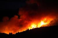
Wildfires have been ravaging large parcels of land in the West and there seems to be no end in sight for the weary Westerners. There are hundreds of individual fires blazing across at least 1.1 million acres in the West. Both the military and foreign firefighting crews have been called in to help the beleaguered firefighters in the West. Washington State’s firefighters are stretched to the limit, and on Friday the state’s Department of Natural Resources (DNR) opened centers in Omak and Colville to coordinate offers of help from trained, qualified volunteer firefighters and from people who have and can operate machinery like backhoes and bulldozers to dig fire lines.
-
-
July 2015 the hottest month on record since measurements began in 1880
Global warming continues unabated. The latest NOAA report notes that July 2015 was warmest month ever recorded for the globe – that is, the warmest month since 1880, when temperature measurements were taken in a systematic fashion for the first time. The July globally averaged land surface temperature was 1.73°F (0.96°C) above the twentieth century average. The year-to-date temperature combined across global land and ocean surfaces was 1.53°F (0.85°C) above the twentieth century average. This was the highest for January–July in the 1880–2015 record, surpassing the previous record set in 2010 by 0.16°F (0.09°C).
-
-
Drought causing California’s San Joaquin Valley land to sink, damaging infrastructure
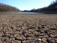
Californians continue pumping groundwater in response to the historic drought, and as a result, land in the San Joaquin Valley is sinking faster than ever before, nearly two inches per month in some locations. Sinking land, known as subsidence, has been occurring for decades in California because of excessive groundwater pumping during drought conditions, but the sinking is happening faster. The increased subsidence rates can damage local, state, and federal infrastructure, including aqueducts, bridges, roads, and flood control structures. Long-term subsidence has already destroyed thousands of public and private groundwater well casings in the San Joaquin Valley. Over time, subsidence can permanently reduce the underground aquifer’s water storage capacity.
-
-
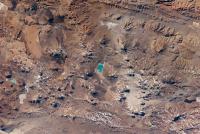
Safe! Claims that an asteroid is threatening earth are unfounded: NASA
Numerous recent blogs and Web postings are claiming that an asteroid will impact Earth, sometime between 15 and 28 September 2015. On one of those dates, as rumors go, there will be an impact — “evidently” near Puerto Rico — causing wide-spread destruction to the Atlantic and Gulf coasts of the United States and Mexico, as well as Central and South America. NASA strongly rejects these unfounded rumors. “There is no scientific basis — not one shred of evidence — that an asteroid or any other celestial object will impact Earth on those dates,” said Paul Chodas, manager of NASA’s Near-Earth Object office.
-
-
Warming climate exacerbating California drought
A new study says that global warming has measurably worsened the ongoing California drought. Scientists largely agree that natural weather variations have caused a lack of rain, but an emerging consensus says that rising temperatures may be making things worse by driving moisture from plants and soil into the air. The new study is the first to estimate how much worse: as much as a quarter. The findings suggest that within a few decades, continually increasing temperatures and resulting moisture losses will push California into even more persistent aridity.
-
-
U.S. coastal flood risk on the rise ten years after Hurricane Katrina
A decade after Hurricane Katrina caused $41 billion in property and casualty insurance losses, the most expensive catastrophe ever experienced by the global insurance industry, rising sea levels are driving up expected economic and insurance losses from hurricane-driven storm surge in coastal cities across the United States. Rising sea levels contributing to increased risk of severe economic damage from flood following a hurricane – and Miami, New York, and Tampa now face greater risk than New Orleans.
-
-
World’s most at-risk coastal regions should adopt Louisiana’s post-Katrina protection plans
A decade after Hurricane Katrina hammered America’s Gulf Coast, measures are being taken there to protect against similar devastation from natural disasters — as well as against long-term, gradual impacts resulting from climate change. Other coastal regions across the world, however, remain vulnerable to damaging storms, and providing similar protection for the tens of millions of people living in those areas — around 38 percent of the global population, or 2.5 billion people, lives within 100 kilometers (62 miles) of the coast — will require international action. Experts say that the world’s most at-risk nations should implement coastal protection plans like those adopted by Louisiana.
-
-
Cascadia initiative gathers information on Northwest Pacific seismic risks
The Cascadia subduction zone (CSZ) is a 680-mile Pacific fault that runs roughly from Cape Mendocino, California in the south to northern Vancouver Island, British Columbia. Early data coming in from a massive, four-year deployment of seismometers onshore and offshore in the Pacific Northwest are giving scientists a clearer picture of the Cascadia subduction zone, a region with a past and potential future of devastating “megathrust” earthquakes.
-
-
New tools increase Palestinians’ capacity to face earthquakes
A massive earthquake would lead to the devastation of 70 percent of houses in the Palestinian territories, and the death of 16 000 people. As the Palestinian territories are located in the Rift Valley — right at the frontier between the Arabian and African plates which are moving farther apart — the likelihood of earthquakes is expected to keep increasing. Two projects aim to make the next generation of citizens and researchers better equipped to face this growing threat.
-
-
Geoengineering technique would not stop sea level rise

Researchers used computer model experiments to test how the Greenland Ice Sheet would react to albedo modification, also called solar radiation management geoengineering, a proposed technology to cool down the Earth’s temperature by reflecting some sunlight away from the planet. They found the ice sheet might contribute to sea-level rise for decades to centuries after albedo modification began. The researchers say that albedo modification should not be counted on as a short-term solution to stop rising global sea levels.
-
-
Up to 30 percent less precipitation in the Central Andes in future
Seasonal water shortages already occur in the Central Andes of Peru and Bolivia. By the end of the century, precipitation could fall by up to 30 percent according to an international team of researchers. Researchers show that precipitation in the rainy season could drop noticeably - and this could happen within the next twenty years.
-
-
Interior Dept.’s National Seed Strategy to guide post-disaster rehabilitation, restoration
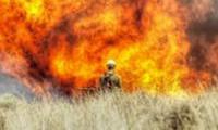
As part of what it describes as a comprehensive, science-based strategy to address the threat of wildfires that are damaging landscapes across the West, the Department of the Interior announced the release of a National Seed Strategy for rehabilitation and restoration to help foster resilient and healthy landscapes. The strategy is meant to guide ecological restoration across major landscapes, especially for those lands damaged by rangeland fires, invasive species, severe storms, and drought.
-
-
Warming-driven substantial glacier ice loss in Central Asia imperils water supplies
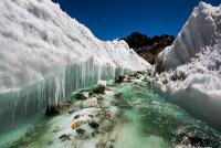
Central Asia is the outstanding case for human dependence on water seasonally delayed by glaciers. Nowhere the question about the glacier state is linked so closely to questions of water availability and, thus, food security. The glaciers in Central Asia, however, experience substantial losses in glacier mass and area. Along the Tien Shan, Central Asia’s largest mountain range, glaciers have lost 27 percent of their mass and 18 percent of their area during the last fifty years. Scientists estimate that almost 3,000 square kilometers of glaciers and an average of 5.4 gigatons of ice per year have been lost since the 1960s, saying that about half of Tien Shan’s glacier volume could be depleted by the 2050s.
-
-
Interior Dept.’s National Seed Strategy to guide post-disaster rehabilitation, restoration
As part of what it describes as a comprehensive, science-based strategy to address the threat of wildfires that are damaging landscapes across the West, the Department of the Interior announced the release of a National Seed Strategy for rehabilitation and restoration to help foster resilient and healthy landscapes. The strategy is meant to guide ecological restoration across major landscapes, especially for those lands damaged by rangeland fires, invasive species, severe storms, and drought.
-
-
In the Pacific Northwest, fear of the Big One should be channeled into pragmatic action
Scientists believe that a magnitude 9.0-plus Cascadia Subduction Zone earthquake — which they call “the largest of the large” — would likely trigger a tsunami that could devastate coastal communities, while the earthquake could destroy infrastructure throughout western Oregon and Washington, including roads, bridges, water and sewer lines, and the power grid. Scientists say, however, that the more probable scenario is an earthquake on “the average side of large,” where the damage is less. Rather than focus on the most extreme scenario – which can lead to fatalism or to people fleeing the region – scientists urge residents of the Pacific Northwest to become pro-active in preparing for a disaster which, if preparations are made, can be survived.
-
The long view
Using Drone Swarms to Fight Forest Fires
Forest fires are becoming increasingly catastrophic across the world, accelerated by climate change. Researchers are using multiple swarms of drones to tackle natural disasters like forest fires.
How Climate Change Will Affect Conflict and U.S. Military Operations
“People talk about climate change as a threat multiplier,” said Karen Sudkamp, an associate director of the Infrastructure, Immigration, and Security Operations Program within the RAND Homeland Security Research Division. “But at what point do we need to start talking about the threat multiplier actually becoming a significant threat all its own?”