-
Bad news for L.A.: Earthquake ruptures can jump much farther than previously thought
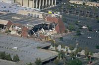
A team of researchers Riverside, has discovered that earthquake ruptures can jump much farther than previously thought, a finding that could have severe implications on the Los Angeles area and other regions in the world. The scientists found that an earthquake that initiates on one thrust fault can spread ten times farther than previously thought to a second nearby thrust fault, vastly expanding the possible range of “earthquake doublets,” or double earthquakes.
-
-
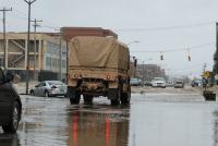
Record Missouri flooding was man-made calamity: Scientists
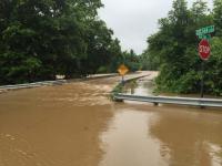
At the end of December 2015, a huge storm named “Goliath” dumped 9-10 inches of rain in a belt across the central United States, centered just southwest of St. Louis, most of it in a three-day downpour. The rain blanketed the Meramec Basin, an area of 4,000 square miles drained by the Meramec River, which enters the Mississippi River south of St. Louis. Why was the flooding so bad? Most news reports blamed it on the heavy rain, but researcher say there was more to the flood than the rain.
-
-
Severe drought no longer caused just by nature
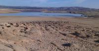
Scientists are calling on drought researchers and managers around the world to consider both human activity and natural phenomena in their battle to preserve increasingly scarce global water supplies. The experts say that severe droughts experienced recently in countries such as China, Brazil and the United States can no longer be seen as purely natural hazards. Changes to the way people use the water and the landscape contribute to extreme water shortages.
-
-
U.S. must address the “wicked problem” of wildfire
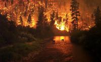
U.S. wildfires burned more than 10.1 million acres in 2015 — a new record. Wildfire suppression costs the United States, on average, $2.9 billion a year. Researchers say that the United States must make preparing for and adapting to wildfire a top national priority, recognizing that widfire is a “wicked problem” — one so complex that a one-size-fits-all solution does not exist.
-
-
Tools to help communities predict, cope with floods
Anticipation and preparedness of large-scale flood events play a key role in mitigating their impacts and optimizing the strategic planning of water resources. Although many countries have well-established systems for river monitoring and early flood warning, an increasing number of inhabitants are affected by floods every year. The Global Flood Awareness System (GloFAS) has been set up providing an overview on upcoming flooding in large world river basins.
-
-
Human-induced climate change helped cause south of England floods: Scientists
Human-induced climate change increased the risk of severe storms like those that hit the south of England in the winter of 2013-14, causing devastating flooding and costing several people their lives. This is according to new analysis from an international team of climate scientists led by researchers at Oxford University.
-
-
Making slums more resilient to climate change

In our rapidly urbanizing world, access to sanitation, transportation, and other essential services remains a challenge for more than a billion people. In the world’s poorest and most vulnerable urban communities, finding new ways to meet these day-to-day human needs not only leads to sustainable development, it also fortifies them against the effects of climate-induced disasters.
-
-
Recent summer temperatures in Europe likely the warmest of the last 2 millennia
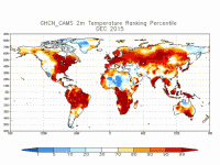
Most of Europe has experienced strong summer warming over the course of the past several decades, accompanied by severe heat waves in 2003, 2010, and 2015. New research now puts the current warmth in a 2,100-year historical context. The evidence suggests that past variability has been associated with large volcanic eruptions and changes in the amount of energy received from the sun, but that temperatures over the past thirty years lie outside the range of these natural variations, supporting the conclusion that recent warming is mainly caused by anthropogenic activity.
-
-
It is 3 minutes to midnight -- still
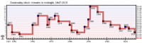
The Bulletin of the Atomic Scientists yesterday announced that the minute hand of the Bulletin’s closely watched Doomsday Clock will remain at three minutes to midnight, since recent progress in the Iran nuclear agreement and the Paris climate accord “constitute only small bright spots in a darker world situation full of potential for catastrophe.” The Bulletin’s panel of security experts said that “Three minutes (to midnight) is too close. Far too close…” – but that this reflects “world leaders continue to fail to focus their efforts and the world’s attention on reducing the extreme danger posed by nuclear weapons and climate change. When we call these dangers existential, that is exactly what we mean: They threaten the very existence of civilization and therefore should be the first order of business for leaders who care about their constituents and their countries.”
-
-
Record warm years almost certainly the result of human-made climate change
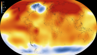
Recent record warm years are with extremely high likelihood caused by human-made climate change. Without greenhouse-gas emissions from burning coal and oil, the odds are vanishingly small that 13 out of the 15 warmest years ever measured would all have happened in the current, still young century. These odds are between 1 in 5,000 and 1 in 170,000, a new study by an international team of scientists now shows. Including the data for 2015, which came in after the study was completed, makes the odds even slimmer.
-
-
Northwestern enhancing local safety with new volunteer emergency response training
Northwestern University says it is enhancing its commitment to the safety of its students, faculty, staff, and visitors by launching a new training session of its Community Emergency Response Team (CERT) program for volunteers this April. The CERT program is a volunteer opportunity and training program for community members to help support preparedness activities, community welfare during major special events and organized community recovery efforts following a crisis.
-
-
Northeast braces for “snowpocalypse”
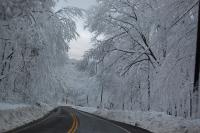
Around seventy-five million Americans are preparing for potentially life-threatening blizzard conditions as the season’s first major Atlantic Coast storm is about to sweep across the East Coast. Forecasters say the storm taking aim at Washington could rank among the biggest snowfalls on record, eclipsing the “Snowmageddon” storm of 2010 that dropped 45.2 cm. At least five states have declared emergencies as the potentially historic blizzard, which is expected to begin today (Friday), will likely dump up to 75 cm of snow in some regions.
-
-
Warmer oceans could produce more powerful, destructive superstorms
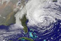
Hurricane Sandy became the second costliest hurricane to hit the United States when it blew ashore in October 2012, killing 159 people and inflicting $71 billion in damage. Informally known as a “superstorm” after it made landfall, Sandy was so destructive largely because of its unusual size and track. After moving north from the tropical waters where it spawned, Sandy turned out to sea before hooking back west, growing in size and crashing head-on into the East Coast, gaining strength when it merged with an eastbound mid-latitude storm. A new study led by the University of Maryland’s Earth System Science Interdisciplinary Center (ESSIC) suggests that a warmer Atlantic Ocean could substantially boost the destructive power of a future superstorm like Sandy.
-
-
Global ocean warming has doubled in recent decades
Changes in ocean heat storage are important because the ocean absorbs more than 90 percent of the Earth’s excess heat increase associated with global warming. Lawrence Livermore (LLNL) scientists, working with National Oceanic and Atmospheric Administration (NOAA) and university colleagues, have found that half of the global ocean heat content increase since 1865 has occurred over the past two decades. The observed ocean and atmosphere warming is a result of continuing greenhouse gas emissions.
-
-
Dead ETs: Aliens are silent because they are all extinct

Life on other planets would likely be brief and become extinct very quickly, say astrobiologists. In research aiming to understand how life might develop, the scientists realized new life would commonly die out due to runaway heating or cooling on their fledgling planets.
-
- All
- Regional
- Water
- Biometrics
- Borders/Immig
- Business
- Cybersecurity
- Detection
- Disasters
- Government
- Infrastructure
- International
- Public health
- Public Safety
- Communication interoperabillity
- Emergency services
- Emergency medical services
- Fire
- First response
- IEDs
- Law Enforcement
- Law Enforcement Technology
- Military technology
- Nonlethal weapons
- Nuclear weapons
- Personal protection equipment
- Police
- Notification /alert systems
- Situational awareness
- Weapons systems
- Sci-Tech
- Sector Reports
- Surveillance
- Transportation
Advertising & Marketing: advertise@newswirepubs.com
Editorial: editor@newswirepubs.com
General: info@newswirepubs.com
2010-2011 © News Wire Publications, LLC News Wire Publications, LLC
220 Old Country Road | Suite 200 | Mineola | New York | 11501
Permissions and Policies
Editorial: editor@newswirepubs.com
General: info@newswirepubs.com
2010-2011 © News Wire Publications, LLC News Wire Publications, LLC
220 Old Country Road | Suite 200 | Mineola | New York | 11501
Permissions and Policies