-
To avoid multiple climate tipping points, CO2 emissions should be stopped by 2050: Study
To avoid multiple climate tipping points, policy makers need to act now to stop global CO2 emissions by 2050 and meet the Paris Agreement’s goal of limiting global warming to 1.5 °C above pre-industrial levels, a new study has said. The new research shows that existing studies have massively under-valued the risk that ongoing carbon dioxide emissions pose of triggering damaging tipping points.
-
-
2015 made history with record heat, weather extremes: WMO
The year 2015 made history, with shattered temperature records, intense heatwaves, exceptional rainfall, devastating drought, and unusual tropical cyclone activity, according to the World Meteorological Organization. That record-breaking trend has continued in 2016. The global average surface temperature in 2015 broke all previous records by a wide margin, at about 0.76° Celsius above the 1961-1990 average because of a powerful El Niño and human-caused global warming. With 93 percent of excess heat stored in the oceans, ocean heat content down to 2,000 meters also hit a new record.
-
-
Increasing speed, accuracy of flood risk assessment
New research hopes to provide advances in the planning for flood risk, thanks to a new, faster method of assessing the highly complex factors that cause floods in a specific location. The results of the study have shown it is possible to increase the speed of a highly accurate flood risk prediction by between 100-1,000 times compared with techniques currently used by researchers to estimate flood risk under climate change.
-
-
February global temperature sets new record for the globe
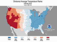
The average temperature for the globe during December-February was 2.03°F above the twentieth century average. This was the highest temperature for December-February in the 1880-2016 record. February 2016 also marks the tenth consecutive month in which a monthly global temperature record has been broken. Record warmth across the globe was aided by a strong El Niño which peaked during the winter.
-
-
Wetland restoration in Midwest would help reduce catastrophic floods
Restoration of wetlands in the Midwest has the potential significantly to reduce peak river flows during floods — not only now, but also in the future if heavy rains continue to increase in intensity. Wetland restoration could also provide a small step toward a hydrologic regime in this region that more closely resembles its historic nature, before roads and cities were constructed, forests were lost, and millions of acres tile-drained to increase agricultural production.
-
-
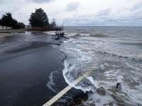
Up to 70 percent of Northeast U.S. coast likely to adapt to rising seas
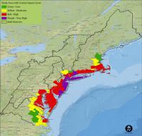
Much of the coast from Maine to Virginia is more likely to change than to simply drown in response to rising seas during the next seventy years or so, according to a new study led by the U.S. Geological Survey. The study is based on a new computer model that captures the potential of the Northeast coast to change, driven by geological and biological forces, in ways that will reshape coastal landscapes.
-
-
Helping policymakers plan for sea level rise
A new study could help protect more than thirteen million American homes that will be threatened by rising sea levels by the end of the century. It is the first major study to assess the risk from rising seas using year 2100 population forecasts for all 319 coastal counties in the continental U.S. Previous impact assessments use current population figures to assess long-term effects of coastal flooding. The data can help policymakers develop practical adaptation strategies for protecting land threatened by frequent and repeated inundation.
-
-
Social media used to assess damage caused by natural disasters
A new study concludes that it is possible to determine the damage caused by a natural disaster in just a few hours by using data from social networks. “Twitter, the social network which we have analyzed, is useful for the management, real-time monitoring and even prediction of the economic impact that disasters like Hurricane Sandy can have,” says one of the researchers.
-
-
Radioactive strontium, cesium from Fukushima continue to leak to the ocean
Scientists investigated the levels of radioactive strontium and cesium in the coast off Japan in September 2013. Radioactive levels in seawater were 10 to 100 times higher than before the nuclear accident, particularly near the facility, suggesting that water containing strontium and cesium isotopes was still leaking into the Pacific Ocean.
-
-
News coverage of Fukushima disaster inadequate
Five years after the 2011 Fukushima Daiichi nuclear disaster in Japan, the disaster no longer dominates U.S. news headlines, although experts say it is a continuing disaster with broad implications. A new analysis finds that U.S. news media coverage following the disaster minimized health risks to the general population.
-
-
The lasting legacies of Chernobyl and Fukushima
It is thirty years since the Chernobyl nuclear disaster. It is also five years since the Fukushima disaster. Greenpeace says that to mark these anniversaries, it has commissioned reviews of scientific studies examining the continued radioactive contamination in the affected areas, and the health and social effects on the impacted populations.
-
-
New laser-based aircraft tracking system to aid in disaster relief efforts
A ground-breaking tracking system called HYPERION, based on eye-safe lasers, could enable aircraft, unmanned aerial vehicles (UAVs), and even orbiting satellites to transmit vital data to ground stations more securely, quickly and efficiently. HYPERION, offering major benefits compared with the traditional radio frequency (RF) data transmission systems currently relied on in the UAV sector, could allow UAVs engaged in disaster monitoring, surveying, search and rescue, and other humanitarian missions to send detailed images more rapidly back to the ground for analysis.
-
-
Sea level rise threatens more people than earlier estimated
It is estimated that 1.9 billion inhabitants, or 28 percent of the world’s total population, live closer than 100 km from the coast in areas less than 100 meters above the present sea level. By 2050 the number of people in that zone is predicted to increase to 2.4 billion. These people are the most vulnerable to the rise of the sea level as well as to the increased number of floods and intensified storms.
-
-
Global warming increases rainfall in world's driest areas
Global warming will increase rainfall in some of the world’s driest areas over land, with not only the wet getting wetter but the dry getting wetter as well — a phenomenon that could lead to more flash flooding.
-
-
Are America's cities prepared for extreme weather events?
Infrastructure is, by design, largely unnoticed until it breaks and service fails. It is the water supply, the gas lines, bridges and dams, phone lines and cell towers, roads and culverts, train lines and railways, and the electric grid; all of the complex systems that keep our society and economy running. Engineers typically design systems to withstand reasonable worst-case conditions based on historical records; for example, an engineer builds a bridge strong enough to withstand floods based on historical rainfall and flooding. But what happens when the worst case is no longer bad enough?
-
The long view
Trump Aims to Shut Down State Climate Policies
President Donald Trump has launched an all-out legal attack on states’ authority to set climate change policy. Climate-focused state leaders say his administration has no legal basis to unravel their efforts.