-
Long-term trend of saltwater intrusion in the Everglades confirmed
Mangroves love salt water, while sawgrass depends on fresh water. Satellite imagery over the southeastern Everglades confirms long-term trends of mangrove expansion and sawgrass habitat loss near the shore. The trend is related to salt water intrusion caused by sea-level rise and water management practices. Changes in water management, such as the implementation of the Comprehensive Everglades Restoration Plan, may help offset the possible effects caused by future salt water intrusion, but restoration may not suffice if sea-level rise accelerates.
-
-
Rural California country faces levee dilemma
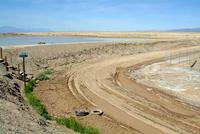
About 400 homes and rich farmland in District-10 of Marysville, California risk being flooded should the levees protecting the area fail. The levees, stretching over twenty-eight miles, were built in the early 1900s. The area’s low population may be one reason why county officials have neglected making improvements to the levees in District-10. Local opponents of investment in shoring up the levees are worried that if the levees are improved and the area made safer, “It would open the door for more agribusiness type things, but it would also open the door for more subdivisions,” in the words of one of them.
-
-
N.J. coastal wetlands moderated some of Hurricane Sandy’s fury
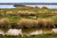
Monitoring sensors along the New Jersey coast recorded marsh and wetland swelling during Hurricane Sandy. That swelling is an indication of marshes’ ability to absorb some of the storm surge — which, in hard-hit urban areas, had resulted in high water marks up to seven feet during Hurricane Sandy. Resilient, healthy wetlands near coastal areas have a key role in protecting local communities from hurricane-induced storm surges and flooding.
-
-
Policies governing rural land use can curb wildfire risks – up to a point
Using Montana’s fast-growing Flathead County as a template, researchers hves found that moderately restrictive land-use policies can significantly curb the potential damage of rural wildfires. Highly restrictive planning laws, however, will not do much more.
-
-
First ever evidence discovered of a comet striking Earth

The first ever evidence of a comet entering Earth’s atmosphere and exploding, raining down a shock wave of fire which obliterated every life form in its path, has been discovered. The comet entered Earth’s atmosphere above Egypt about twenty-eight million years ago. As it entered the atmosphere, it exploded, heating up the sand beneath it to a temperature of about 2,000 degrees Celsius, and resulting in the formation of a huge amount of yellow silica glass which lies scattered over a 6,000 square kilometer area in the Sahara.
-
-
U.S. nation-wide quake early-warning system
The United States is likely to be struck by a major earthquake within the next twenty years. Scientists say that instead of waiting to experience a devastating earthquake and then invest in preventative measures for subsequent earthquakes, the country should be proactive and take action before the event. Investing in a nationwide earthquake warning system will save lives, prevent destruction of key infrastructure, and reduce the size of the economic loss that may result from an earthquake.
-
-
Bolstering water security in a crowded world
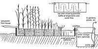
With limited water and the increasing number of people depending on it – there will be more than nine billion people on the planet by 2050 — water security is tenuous. Integrated water management plans using “blue,” “green,” and “gray” water, however, can increase water security by allowing agriculture to rise to the challenge of feeding a growing world population while leaving enough water for other uses.
-
-
How one transportation company survived Hurricane Sandy
In a year-long case study of a major American transportation company, researchers have uncovered the strategies that helped the company maintain safety and meet customer demand during 2012’s Hurricane Sandy. One key to the company’s effective response was its setup of a weather event management team, an ad hoc group that set planning priorities as the storm approached the United States, ensuring the protection of personnel and equipment in hurricane’s path.
-
-
Delaware prepares for sea-level rise
Benjamin Franklin said that that an ounce of prevention is worth a pound of cure, and Governor Jack Markell of Delaware agrees. Two weeks ago he unveiled an initiative aiming to prepare his state for the effects of climate change and sea-level rise. Markell has signed an executive order requiring all state agencies to take sea-level rise into account when designing and locating state projects. The order also requires development of strategies to make state facilities and operations better prepared to deal with climate change and sea-level rise.
-
-
Tiny smartphone sensors create an urban seismic network
A tiny chip used in smart phones to adjust the orientation of the screen could serve to create a real-time urban seismic network, easily increasing the amount of strong motion data collected during a large earthquake. This urban seismic network could transmit in real-time ground motion data to a central location for assessment. The rich volume of data could help first responders identify areas of greatest potential damage, allowing them to allocate resources more effectively.
-
-
Building disaster-relief phone apps on the fly
Researchers combine powerful new Web standards with the intuitive, graphical MIT App Inventor to aid relief workers with little programming expertise.
-
-
NYC enacts post-Sandy resiliency codes
Last week the New York City Council enacted laws implementing five recommendations of the Building Resiliency Task Force, led by Urban Green Council following Superstorm Sandy. This first package of laws makes NYC better prepared for future hurricanes and extreme weather.
-
-
NSF awards first coastal sustainability grants
More than half the world’s human population lived in coastal areas in the year 2000; that percentage is expected to rise to 75 percent by 2025. In wake of storms such as Hurricane Sandy, NSF grants will lead to better management of coastal environments.
-
-
How Sandy has changed storm warning procedures
Superstorm Sandy slammed against the U.S. Eastern Seaboard in October 2012, inundating iconic communities. Those communities have been rebuilding since then and things are almost back to normal for most. Something else, however, has had to be rebuilt as well: the structured procedures for issuing warnings. The goal is to help communities better comprehend what natural disasters will bring their doorsteps.
-
-
Fracking in Ohio: tapping a valuable resource or invading the environment?
A new study is examining methane and other components in groundwater wells, in advance of drilling for shale gas which is expected over the next several years in an Ohio region. A team of researchers spent a year doing periodic testing of groundwater wells in Carroll County, Ohio, a section of Ohio that sits along the shale-rich Pennsylvania-West Virginia borders. The study analyzed twenty-five groundwater wells at varying distances from proposed fracking sites in the rural, Appalachian, Utica Shale region of Carroll County.
-
The long view
Using Drone Swarms to Fight Forest Fires
Forest fires are becoming increasingly catastrophic across the world, accelerated by climate change. Researchers are using multiple swarms of drones to tackle natural disasters like forest fires.
How Climate Change Will Affect Conflict and U.S. Military Operations
“People talk about climate change as a threat multiplier,” said Karen Sudkamp, an associate director of the Infrastructure, Immigration, and Security Operations Program within the RAND Homeland Security Research Division. “But at what point do we need to start talking about the threat multiplier actually becoming a significant threat all its own?”