-
What use are apps when your web infrastructure is underwater?
This winter has seen unprecedented high winds and flooding resulting in widespread and in some cases, long-lasting power outages in the United Kingdom, particularly in the west of England. Time and time again, companies have advised their customers to go online to check their Web sites for the latest information. Some organizations have even created apps specifically designed to assist flood victims; others have established Facebook self-help groups. There is a fundamental problem here: There are two primary ways in which we gain access to the Web, via a landline and using a mobile connection. Within our homes the landline connects to a wireless router and also, for a lot of homes, a cordless telephone, both of which need electrical power to work. So, when the lights go out, your router and cordless phones are useless. The result is that at times of crisis, the customers in most need are often the ones with no access.
-
-
Real-time forecast of Hurricane Sandy accurately predicted storm’s track, intensity
A real-time hurricane analysis and prediction system that effectively incorporates airborne Doppler radar information may accurately track the path, intensity, and wind force in a hurricane. This system also can identify the sources of forecast uncertainty.
-
-
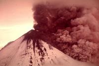
Volcanoes can go from dormant to active quickly
A new study suggests that the magma sitting 4-5 kilometers beneath the surface of Oregon’s Mount Hood has been stored in near-solid conditions for thousands of years, but that the time it takes to liquefy and potentially erupt is surprisingly short — perhaps as little as a couple of months. The key, scientists say, is to elevate the temperature of the rock to more than 750 degrees Celsius, which can happen when hot magma from deep within the Earth’s crust rises to the surface.
-
-
Volcanic eruptions explain recent warming hiatus
Volcanic eruptions in the early part of the twenty-first century have cooled the planet, according to a study led by Lawrence Livermore National Laboratory. This cooling has partly offset the warming produced by greenhouse gases, explaining why, despite continuing increases in atmospheric levels of greenhouse gases, and in the total heat content of the ocean, global-mean temperatures at the surface of the planet and in the troposphere (the lowest portion of the Earth’s atmosphere) have shown relatively little warming since 1998. Scientists note that human-induced – that is, greenhouse gasses emissions-related — change typically causes the troposphere to warm and the stratosphere to cool. In contrast, large volcanic eruptions cool the troposphere and warm the stratosphere.
-
-
Unsupervised robotic construction crew to build flood defenses
On the plains of Namibia, millions of tiny termites are building a mound of soil — an 8-foot-tall “lung” for their underground nest. They do so without a supervisor, foreman, or CEO to tell them what to do. During a year of construction, many termites will live and die, wind and rain will erode the structure, and yet the colony’s life-sustaining project will continue. Harvard researchers, inspired by the termites’ resilience and collective intelligence, have created an autonomous robotic construction crew. The system needs no supervisor, no eye in the sky, and no communication: just simple robots — any number of robots — that cooperate by modifying their environment. In the future, similar robots could lay sandbags in advance of a flood, or perform simple construction tasks on Mars.
-
-
Large offshore wind farms could weaken hurricanes before they make landfall
Computer simulations have shown that offshore wind farms with thousands of wind turbines could have sapped the power of three real-life hurricanes, significantly decreasing their winds and accompanying storm surge, and possibly preventing billions of dollars in damages. For example, an array of 78,000 wind turbines off the coast of New Orleans would have significantly weakened Hurricane Katrina well before it made landfall, reducing wind speeds between 80 and 98 mph, and decreasing the storm surge by up to 79 percent.
-
-
Protecting the grid from geomagnetic storms
A geomagnetic storm disrupts the Earth’s magnetic field by producing geomagnetically induced currents (GICs) on the Earth’s surface, which can enter the power grid at transformer stations and move along power lines, disrupting normal operations. A geomagnetic storm would reach Earth between fourteen and ninety-six hours, leaving little time to safeguard critical infrastructure. U.S. regulators are drafting reliability standards and procedures to protect the U.S. power grid from such storms.
-
-
Limitations and side effects of large-scale geoengineering
Despite international agreements on climate protection and political declarations of intent, global greenhouse gas emissions have not decreased, and with the accelerating industrialization of emerging markets, are not likely to any time soon. Therefore, large-scale methods – called geoengineering or climate engineering — artificially to slow down global warming are increasingly being discussed. Scientists say that the long-term consequences and side effects of these methods have not been adequately studied.
-
-
Damage to coastal infrastructure from storm surges, floods may reach 9% of global GDP
Damage to the world’s coastal infrastructure as a result of flooding, sea level rise, and coastline development is expected to cost as much as 9 percent of global Gross Domestic Product (GDP) according to a new report published in the Proceedings of the National Academy of Sciences(PNAS).
-
-
Studying the 2011 Mississippi and Ohio rivers flood for better flood preparedness
In May 2011, when the U.S. Army Corps of Engineers used explosives to breach a levee south of Cairo, Illinois, diverting the rising waters of the Mississippi and Ohio rivers to prevent flooding in the town, about 130,000 acres of Missouri farmland were inundated. It was the largest flood of the lower Mississippi ever recorded. Researchers took advantage of this “once-in-a-scientific-lifetime” occurrence to study the damage in order to demonstrate that landscape vulnerabilities can be mapped ahead of time to help communities prepare for extreme flooding.
-
-
Implementing solar radiation management, then stopping, would accelerate climate change
One geoengineering approach to slowing or reversing climate change is solar radiation management, which envisions spraying tiny sulfur-based particles into the upper atmosphere to reflect sunlight. This is similar to what happens after a major volcanic eruption, and many experts believe the technique is economically and technically feasible. Continuous implementation over years, however, depends on technical functioning, continuous funding, bureaucratic agreement, and lack of negative side effects. In a new study, researchers say that spraying reflective particles into the atmosphere to reflect sunlight and then stopping it could exacerbate the problem of climate change.
-
-
Fashioning an effective disaster mitigation approach in an uncertain world
The dramatic images of natural disasters show that nature, not the people preparing for hazards, often wins the high-stakes game of chance. Sometimes nature surprises us when an earthquake, hurricane, or flood is bigger or has greater effects than expected. In other cases, nature outsmarts us, doing great damage despite expensive mitigation measures or causing us to divert limited resources to mitigate hazards that are overestimated. Much of the problem comes from the fact that formulating effective natural hazard policy involves combining science, economics, and risk analysis to analyze a problem and explore costs and benefits of different options in situations where the future is very uncertain.
-
-
Power cuts will be more common in the future
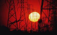
U.S. figures show that since 2007, commercial and domestic air-conditioning alone consumed 484billion kilowatt hours of electricity — not much more than the country’s total energy consumption in the mid-1950s. The American Society of Civil Engineers (ASCE) has warned that U.S. generation systems could collapse by 2020 without $100 billion of new investment in power stations. Demands of high-powered electrical appliances, a growing world population, and inadequate investment in the power sector will create more frequent power blackouts in Western societies.
-
-
Protecting Earth from menacing asteroids
Tracking near-Earth asteroids has been a significant endeavor for NASA and the broader astronomical community, which has discovered 10,713 known near-Earth objects (NEO) to date. NASA says that it is now pursuing new partnerships and collaborations in an Asteroid Grand Challenge to accelerate NASA’s existing planetary defense work, which will help find all asteroid threats to human population and know what to do about them. In parallel, NASA is developing an Asteroid Redirect Mission (ARM) — a first-ever mission to identify, capture, and redirect an asteroid to a safe orbit of Earth’s moon for future exploration by astronauts in the 2020s.
-
-
Santa Monica to identify, require retrofitting for, quake-vulnerable buildings
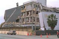
Twenty years ago the city of Santa Monica, California passed laws requiring retrofitting of concrete, steel, and wood apartment buildings which were likely to collapse during an earthquake. The city stopped enforcing the laws a few years after it was passed. Beginning this year, Santa Monica will inspect, and require seismic retrofitting for, concrete, steel, and wood-frame buildings deemed vulnerable during a major earthquake.
-
- All
- Regional
- Water
- Biometrics
- Borders/Immig
- Business
- Cybersecurity
- Detection
- Disasters
- Government
- Infrastructure
- International
- Public health
- Public Safety
- Communication interoperabillity
- Emergency services
- Emergency medical services
- Fire
- First response
- IEDs
- Law Enforcement
- Law Enforcement Technology
- Military technology
- Nonlethal weapons
- Nuclear weapons
- Personal protection equipment
- Police
- Notification /alert systems
- Situational awareness
- Weapons systems
- Sci-Tech
- Sector Reports
- Surveillance
- Transportation
Advertising & Marketing: advertise@newswirepubs.com
Editorial: editor@newswirepubs.com
General: info@newswirepubs.com
2010-2011 © News Wire Publications, LLC News Wire Publications, LLC
220 Old Country Road | Suite 200 | Mineola | New York | 11501
Permissions and Policies
Editorial: editor@newswirepubs.com
General: info@newswirepubs.com
2010-2011 © News Wire Publications, LLC News Wire Publications, LLC
220 Old Country Road | Suite 200 | Mineola | New York | 11501
Permissions and Policies