-
Know when to go: a new way to keep firefighters safe from harm
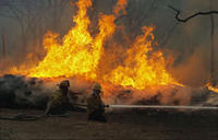
For a firefighter, knowing when it’s time to evacuate can be the difference between life and death. But that can be a difficult call to make when you’re trying to protect life, property and resources while battling wildfires in arduous weather and terrain. Whether working at the fire’s edge or creating a fire break far from the front, firefighters must maintain situational awareness and monitor impending threats to their safety. When firefighters are unable to properly recognize risks, or they underestimate conditions, the results can be tragic.
-
-
Toxins-breathing bacteria to help industry, environment
Preliminary tests suggest that the bacteria could be used to remove these pollutants from the wastewater and protect the surrounding ecosystems. Buried deep in the mud along the banks of a remote salt lake near Yosemite National Park are colonies of bacteria with an unusual property: they breathe a toxic metal to survive. Researchers believe that this unusual organism may one day become a useful tool for industry and environmental protection – for example, the bacteria could be used simply to clean up the water, but it might also be possible for the bacteria to help humans recover and recycle the valuable elements in the water.
-
-
New L.A. fault map threatens Hollywood development projects
The state of California recently released new geological maps which reveal the presence of an active earthquake fault along the path of major developments in Hollywood. The maps established a zone of 500 feet on both sides of the fault, and state law will require new developments within the zone to conduct underground seismic testing to determine whether the fault runs beneath planned development sites. Building on top of faults is prohibited. Three prominent Hollywood developments — the Millennium Hollywood skyscraper project, the Blvd6200 development, and an apartment project on Yucca Street — are within the 500-foot fault zone.
-
-
Massachusetts takes steps to withstand climate change impacts
Governor Deval Patrick of Massachusetts earlier this week unveiled a $50 million plan to help prepare Massachusetts for the challenges climate change poses to energy supplies, public health, transportation, and basic infrastructure in his state. A $40 million grant from the state’s Department of Energy Resources will help cities and towns develop protections around energy services, and $10 million will go toward shoring up critical coastal infrastructure and dam repair.
-
-
Autonomous drones to help in search and rescue, disaster relief
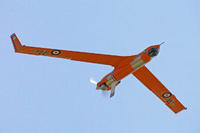
Research could soon enable unmanned aerial vehicles (UAVs) to track down missing persons on search-and-rescue missions, to penetrate curtains of smoke during wildfire suppression, or possibly even to navigate urban landscapes on delivery runs for online retailers like Amazon. It all could be done autonomously with a human acting only as a supervisor. “Drones have gotten a very bad rap for various reasons,” says Kelly Cohen, associate professor of aerospace engineering and engineering mechanics at the University of Cincinnati. “But our students see that unmanned systems can have a positive impact on society.”
-
-
Robots compete in performing emergency response task

Sixteen robots participating in the DARPA Robotics Challenge Trials last month performed such tasks as opening doors or climbing a ladder, all tasks aimed to speed the development of robots that could one day perform a number of critical, real-world, emergency response tasks at natural and human-made disaster sites. While most of the entries were engineered to resemble humanoids with two legs, JPL’s RoboSimian tackled tasks like climbing over rough terrain on all four of its limbs.
-
-
The causes of recent Caribbean earthquakes
A 6.4-magnitude earthquake shook Puerto Rico Monday 13 January. It caused some power outages and cracked floors, but no major damage or injuries were reported. The quake, which struck the northern coastal town of Hatillo, is one of the largest to hit the U.S. territory in recent years. This event comes four days after a 5.0-magnitude earthquake rattled Havana, Cuba. Researchers say that the earthquake in Puerto Rico occurred on the North American-Caribbean plate boundary, whereas the earthquake in Cuba happened well inside the North American plate. Although inter-plate earthquakes do occur, often on older faults that are reactivated, they are less common than those that form at plate boundaries.
-
-
Using building “belt” cheaply, quickly to repair of earthquake damage
Four years after the January 2010 earthquake, 145,000 people still remain homeless in Haiti. Researchers developed a cheap and simple technology to repair earthquake damaged buildings to help to reduce these delays by quickly making buildings safe and habitable. The technology involves wrapping metal straps around each floor of the building, which are then tensioned either by hand or using compressed air tools. Unlike other repair methods, it does not require expensive materials or a high level of technical knowledge, making it ideal for use in the developing world.
-
-
U.S. disaster preparedness threatened by funding problems
The 9/11 attacks in New York City prompted large increases in government funding to help communities respond and recover after man-made and natural disasters. This funding, however, has fallen considerably since the economic crisis in 2008. Furthermore, disaster funding distribution is deeply inefficient: huge cash infusions are disbursed right after a disaster, only to fall abruptly after interest wanes. These issues have exposed significant problems with our nation’s preparedness for public health emergencies. Researchers list seven recommendations to enhance preparedness for public health emergencies in the U.S.
-
-
Europe facing more severe and persistent droughts
Drought is a major natural disaster that can have considerable impacts on society, the environment, and the economy. In Europe alone, the cost of drought over the past three decades has amounted to over 100 billion euros. Europe has been battered by storms in the last few years, but researchers warn that many river basins, especially in southern parts of Europe, are likely to become more prone to periods of reduced water supply due to climate change. An increasing demand for water, following a growing population and intensive use of water for irrigation and industry, will result in even stronger reductions in river flow levels.
-
-
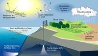
Geoengineering measures to cool the planet would cause climate chaos
Geoengineering — the intentional manipulation of the climate to counter the effect of global warming — is being proposed as a last-ditch way to deal with the problems of climate change. New research suggests geoengineering could cause massive changes to rainfall patterns around the equator, drying the tropical rainforests in South America and Asia, and intensifying periods of drought in Africa.
-
-
2013 natural catastrophes dominated by extreme weather in Europe, Supertyphoon Haiyan
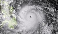
Exceptionally high losses from weather-related catastrophes in Europe and Supertyphoon Haiyan dominated the overall picture of natural catastrophes in 2013. Floods and hailstorms caused double-digit billion-dollar losses in central Europe, and in the Philippines one of the strongest cyclones in history, Supertyphoon Haiyan, resulted in a human catastrophe with over 6,000 fatalities.
-
-
New phone alerts for extreme weather events may prevent casualties in India
India has a mobile phone subscriber base exceeding 929 million people and this is expected to touch 1.15 billion by the end of 2014. An alert system developed for mobiles could reach an estimated 97 percent of the population. Computer science undergraduates have created image-based mobile phone alerts, connected to the Weather Research and Forecasting system.
-
-
Abandoned mine offers clues about permanent CO2 sequestration
Power plants and other industries are responsible for more than 60 percent of global CO2 emissions, according to the International Energy Agency. Sequestering the CO2 in magnesite deposits would prevent the gas from entering the atmosphere and warming the planet. Stanford University researchers, studyingveins of pure magnesium carbonate, or magnesite — a chalky mineral made of carbon dioxide (CO2) and magnesium – in an abandoned mine in the Red Mountain, propose a novel technique for converting CO2 into solid magnesite, making CO2 sequestration feasible.
-
-
Relying on geoengineering to reduce climate change unlikely to succeed
Reducing the amount of sunlight reaching the planet’s surface by geoengineering may not undo climate change after all. Researchers used a simple energy balance analysis to explain how the Earth’s water cycle responds differently to heating by sunlight than it does to warming due to a stronger atmospheric greenhouse effect. Further, they show that this difference implies that reflecting sunlight to reduce temperatures may have unwanted effects on the Earth’s rainfall patterns.
-
- All
- Regional
- Water
- Biometrics
- Borders/Immig
- Business
- Cybersecurity
- Detection
- Disasters
- Government
- Infrastructure
- International
- Public health
- Public Safety
- Communication interoperabillity
- Emergency services
- Emergency medical services
- Fire
- First response
- IEDs
- Law Enforcement
- Law Enforcement Technology
- Military technology
- Nonlethal weapons
- Nuclear weapons
- Personal protection equipment
- Police
- Notification /alert systems
- Situational awareness
- Weapons systems
- Sci-Tech
- Sector Reports
- Surveillance
- Transportation
Advertising & Marketing: advertise@newswirepubs.com
Editorial: editor@newswirepubs.com
General: info@newswirepubs.com
2010-2011 © News Wire Publications, LLC News Wire Publications, LLC
220 Old Country Road | Suite 200 | Mineola | New York | 11501
Permissions and Policies
Editorial: editor@newswirepubs.com
General: info@newswirepubs.com
2010-2011 © News Wire Publications, LLC News Wire Publications, LLC
220 Old Country Road | Suite 200 | Mineola | New York | 11501
Permissions and Policies